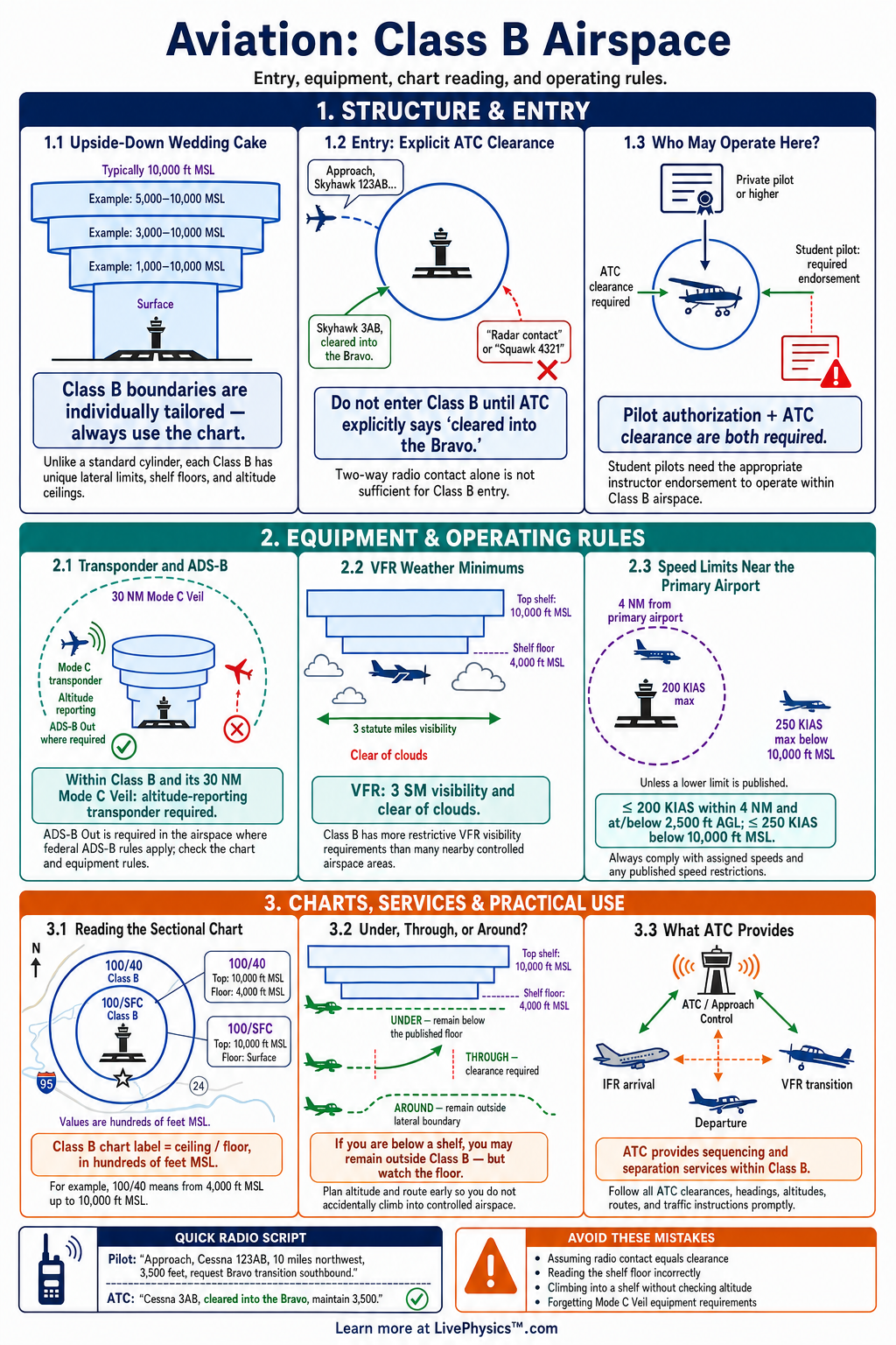
Class B airspace is controlled airspace built around the nation’s busiest airports. This cheat sheet helps pilots quickly identify Class B boundaries, understand entry rules, and communicate correctly with air traffic control. It is designed as a practical reference for student pilots, written tests, checkrides, and flight planning.
Class B airspace usually has a layered shape that is wider at higher altitudes and tighter near the primary airport. Pilots need an explicit ATC clearance before entering, unlike some other controlled airspace classes. Key topics include chart symbols, altitude limits, transponder and ADS-B requirements, weather minimums, and VFR procedures.
Key Facts
- A pilot must receive an explicit ATC clearance before entering Class B airspace.
- Class B airspace is shown by solid blue boundary lines on sectional and terminal area charts.
- A Class B sector labeled 100 over 40 extends from 4,000 feet mean sea level to 10,000 feet mean sea level.
- The basic VFR weather minimum in Class B airspace is 3 statute miles visibility and clear of clouds.
- Class B airspace normally requires two way radio communication, an altitude reporting transponder, and ADS-B Out equipment.
- The Mode C veil generally requires an altitude reporting transponder within 30 nautical miles of the primary Class B airport from the surface to 10,000 feet mean sea level.
- ATC provides separation to all aircraft operating within Class B airspace.
- A pilot may fly beneath a Class B shelf when the aircraft remains below the published floor and outside all Class B boundaries.
Vocabulary
- Class B airspace
- Controlled airspace surrounding a very busy airport where ATC separates all aircraft and explicit clearance is required for entry.
- Class B shelf
- An outer layer of Class B airspace with a floor above the surface that allows aircraft to fly below it.
- Mode C veil
- Airspace around many Class B airports where an altitude reporting transponder is generally required.
- ATC clearance
- Authorization from air traffic control to conduct a specified operation, such as entering Class B airspace.
- ADS-B Out
- Aircraft equipment that broadcasts the aircraft’s identity, position, altitude, and velocity to ATC and other properly equipped aircraft.
- Terminal area chart
- A detailed aeronautical chart that shows complex airspace, airports, routes, and obstacles around major terminal areas.
Common Mistakes to Avoid
- Entering after ATC says to standby is wrong because standby only means the controller has not yet issued a Class B entry clearance.
- Reading a Class B altitude label as height above ground is wrong because the published ceiling and floor are stated in feet mean sea level.
- Assuming radio contact alone permits entry is wrong because Class B requires an explicit clearance, not merely two way communication.
- Flying too close to a shelf while waiting for clearance is risky because a small altitude or navigation error can cause an unauthorized airspace entry.
- Using the standard cloud clearance distances from other airspace classes is wrong because the Class B VFR requirement is 3 statute miles visibility and clear of clouds.
Practice Questions
- 1 A Class B sector is labeled 100 over 40. State the floor and ceiling of that sector in feet mean sea level.
- 2 An aircraft is 22 nautical miles from a Class B primary airport and flying at 5,500 feet mean sea level. If the local Class B shelf begins at 6,000 feet mean sea level, determine whether the aircraft is inside that shelf.
- 3 State the basic VFR visibility and cloud clearance requirements for operating inside Class B airspace.
- 4 ATC tells a VFR pilot to remain outside Class Bravo and says that a clearance will follow. Explain what the pilot should do and why.
Understanding Class B Airspace
Class B airspace protects the heavy flow of airline, cargo, business, and general aviation traffic around major airports. It gives air traffic control the tools to separate every aircraft operating inside its boundaries. The airspace often resembles an upside down wedding cake, with several shelves that expand outward as altitude increases.
Its exact size and altitude limits vary by city. Pilots must study the sectional chart, terminal area chart, and published procedures for the specific Class B area before flight.
The most important entry rule is simple. A pilot must receive an explicit clearance from ATC before crossing a Class B boundary. A controller saying to standby, remain outside, or ident does not authorize entry.
The required phrase is usually clear, such as cleared into the Class Bravo. Pilots should establish communication early, state their position, altitude, aircraft type, destination, and request. Waiting until close to the boundary can create an unsafe situation because ATC may need time to fit the aircraft into traffic.
Class B airspace normally extends from the surface to a published upper altitude. Blue solid boundary lines mark it on a sectional chart. Numbers in each sector show the ceiling and floor in hundreds of feet mean sea level.
A sector labeled 100 over 40 extends from 4,000 feet mean sea level up to 10,000 feet mean sea level. Some outer shelves have floors above the ground, so an aircraft may legally fly beneath them without entering Class B airspace. Pilots must compare their actual altitude with both limits and remember that terrain elevation affects height above ground.
Most aircraft entering Class B need an operable two way radio and a Mode C transponder with altitude reporting. ADS-B Out is also required in most Class B airspace and within the surrounding Mode C veil. VFR weather minimums in Class B are three statute miles visibility and clear of clouds.
There is no standard minimum cloud distance because ATC provides separation to all aircraft. A student pilot may operate in Class B only with the required instructor endorsements and any airport specific training required by regulation.
Good Class B operations depend on planning and precise flying. Review frequencies, likely entry points, runway flow, charted VFR routes, and alternate routes before departure. Keep headings and altitudes accurate after receiving a clearance, since small deviations can conflict with fast traffic.
Listen carefully for frequency changes and read back clearances that affect routing, altitude, or runway use. If a clearance is delayed or denied, remain outside the boundary, advise ATC of your intentions, and use a safe alternative route.