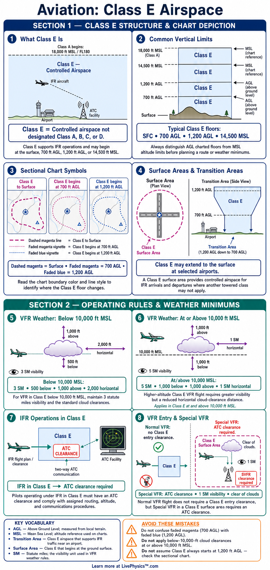
Class E airspace is controlled airspace that covers a large part of the United States. Student pilots need to recognize its boundaries on sectional charts and understand when it begins above the ground. This cheat sheet organizes the key chart symbols, altitude limits, weather rules, and operating requirements for quick review before flight planning.
Class E has several possible floors, including the surface, 700 feet AGL, 1,200 feet AGL, and 14,500 feet MSL. VFR pilots usually may enter without a clearance, but they must meet visibility and cloud-clearance rules. IFR pilots need an ATC clearance, and all pilots must remain alert for other aircraft.
Key Facts
- Where no lower Class E floor is charted, Class E begins at 14,500 feet MSL and extends to but does not include 18,000 feet MSL.
- A blue shaded boundary on a sectional chart shows Class E beginning at 1,200 feet AGL.
- A magenta shaded boundary on a sectional chart shows Class E beginning at 700 feet AGL.
- A dashed magenta boundary shows a Class E surface area that begins at the surface.
- Below 10,000 feet MSL, basic VFR weather minimums are 3 statute miles visibility, 500 feet below clouds, 1,000 feet above clouds, and 2,000 feet horizontal from clouds.
- At or above 10,000 feet MSL, except within 1,200 feet AGL, VFR weather minimums are 5 statute miles visibility, 1,000 feet below clouds, 1,000 feet above clouds, and 1 statute mile horizontal from clouds.
- An IFR aircraft must have an ATC clearance to operate in Class E airspace.
- A VFR aircraft normally does not need an ATC clearance or radio contact to enter Class E, but it must meet all applicable weather and operating rules.
Vocabulary
- Controlled airspace
- Controlled airspace is airspace where air traffic control provides services to aircraft operating under specified rules.
- MSL
- Mean sea level is an altitude reference measured from average sea level.
- AGL
- Above ground level is a height reference measured from the surface directly below the aircraft.
- VFR
- Visual flight rules are regulations that allow pilots to navigate primarily by outside visual reference when weather conditions are adequate.
- IFR
- Instrument flight rules are regulations used when a pilot operates with ATC clearance and relies on instruments and navigation systems.
- Class E surface area
- A Class E surface area is controlled airspace that starts at the surface, usually to support IFR operations at an airport.
Common Mistakes to Avoid
- Confusing AGL with MSL causes pilots to use the wrong Class E floor. Charted 700-foot and 1,200-foot floors are measured above the ground, while the 14,500-foot floor is measured MSL.
- Treating every blue or magenta chart boundary as the same airspace floor is wrong. Blue shading indicates 1,200 feet AGL, while magenta shading indicates 700 feet AGL.
- Assuming VFR pilots have no weather requirements in Class E is incorrect. VFR aircraft must maintain the required visibility and distance from clouds.
- Believing that a radio call is required before every VFR entry into Class E is incorrect. Class E normally has no communication requirement for VFR entry unless another rule or procedure applies.
- Flying at 18,000 feet MSL while calling the airspace Class E is incorrect. Class A begins at 18,000 feet MSL, so IFR rules and an ATC clearance apply.
Practice Questions
- 1 A sectional chart shows Class E beginning at 700 feet AGL, and the terrain elevation is 600 feet MSL. Determine the MSL altitude where Class E begins.
- 2 A VFR airplane cruises at 8,500 feet MSL in Class E. State the required minimum visibility and cloud clearances.
- 3 An airplane operates at 11,500 feet MSL and more than 1,200 feet AGL in Class E. State the required VFR visibility and cloud clearances.
- 4 Explain why a VFR pilot should still maintain careful visual scanning in Class E even though ATC generally does not require a clearance for VFR entry.
Understanding Class E Airspace
Class E is controlled airspace, but it is less restrictive for visual flight rules pilots than Classes B, C, or D. It fills much of the airspace between local airport areas and Class A airspace. Its purpose is to protect instrument flight rules traffic, especially traffic arriving at or departing from airports served by instrument procedures.
A pilot must identify where Class E begins because its floor changes from place to place. This affects weather planning, cloud clearance, and the services an air traffic control facility may provide.
On most sectional charts, the standard Class E floor is 1,200 feet above ground level and is shown by a blue shaded boundary. A magenta shaded boundary marks Class E that starts at 700 feet above ground level. A dashed magenta boundary encloses Class E that reaches the surface, often around an airport with weather reporting and instrument approaches.
In areas without a lower charted floor, Class E normally begins at 14,500 feet mean sea level. It continues upward to but does not include 18,000 feet mean sea level, where Class A begins.
VFR pilots usually do not need an air traffic control clearance or two way radio contact to enter Class E. They still must meet the basic VFR weather minimums and follow all other applicable regulations. Below 10,000 feet mean sea level, these minimums are three statute miles visibility, 500 feet below clouds, 1,000 feet above clouds, and 2,000 feet horizontal from clouds.
At or above 10,000 feet mean sea level, greater visibility and cloud separation are required except when operating within 1,200 feet above the surface. Pilots should use the current regulations because special airspace and airport rules can add requirements.
IFR aircraft need an ATC clearance before operating in Class E, and ATC separates IFR traffic from other IFR traffic. ATC does not provide the same separation from VFR aircraft, so alert scanning remains important for every pilot. Class E surface areas deserve close attention because weather can change quickly near an instrument airport.
A VFR pilot may fly there without a clearance when weather is legal, but must not enter clouds or create a hazard. When studying, pair each chart symbol with its floor, then practice applying the correct weather rule using altitude in mean sea level and height above ground level.