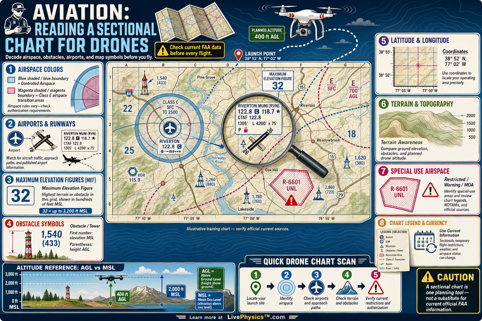
A sectional chart is a detailed aeronautical map used by pilots to understand terrain, airports, airspace, obstacles, and navigation features. Drone pilots need it because a flight that looks clear from the ground may lie near controlled airspace, tall towers, or rising terrain. Reading the chart helps a pilot plan a safer route and avoid airspace violations.
It also builds the situational awareness needed for responsible drone operations.
The most important skill is connecting chart symbols to the real landscape and to current flight rules. Airspace colors and boundary lines show where special authorization may be required, while altitude labels show the vertical limits of that airspace. Airport symbols, communication frequencies, and obstacle markings reveal places where crewed aircraft may be active.
A sectional chart supports planning, but drone pilots must still check current notices, weather, and authorization tools before launch.
Understanding Aviation, Reading a Sectional Chart for Drones
Sectional charts use a standard scale of one to five hundred thousand. They cover a large area while retaining navigation details that matter to low altitude pilots. The chart base shows terrain, rivers, roads, cities, railroads, obstacles, and elevation data.
A drone pilot uses these features to locate the launch site, predict line of sight issues, and select emergency landing areas. The map is a planning tool, not a live display of every condition.
Airspace boundaries are the first symbols to identify. Solid blue lines outline Class B airspace, usually surrounding the busiest airports. Solid magenta lines identify Class C airspace, while blue dashed lines identify Class D airspace around many control towers.
These controlled areas generally require FAA authorization for drone flight. A magenta dashed boundary can indicate Class E airspace beginning at the surface, which can require authorization even when the location seems far from a major airport.
Numbers on sectional charts need careful interpretation. Most airspace altitude labels are shown in hundreds of feet above mean sea level, often called MSL. A label of 100 over 30 describes airspace extending from 3,000 feet MSL up to 10,000 feet MSL.
This differs from the usual drone altitude limit, which is measured above ground level, or AGL. Pilots must compare local terrain elevation, airport elevation, and airspace floors before deciding whether a planned altitude fits safely below controlled airspace.
Airport symbols provide useful warnings even outside controlled airspace. Blue airport symbols usually indicate an airport with an operating control tower. Magenta airport symbols usually represent an airport without a tower.
Runway layouts, field elevation, lighting information, and nearby frequencies may be printed beside the symbol. A drone pilot should expect crewed aircraft near any airport, including helicopters, agricultural aircraft, and aircraft approaching a runway from several miles away.
Obstruction symbols mark towers, antennas, and other tall structures that can be hard to see from a distance. A chart may show an obstacle elevation above mean sea level, plus a smaller height above ground level.
Learn to use the chart with current FAA notices, temporary flight restriction information, weather reports, and airspace authorization services. In real planning, start at the intended launch point, trace outward along the flight area, identify airspace and obstacles, then confirm that the information is current on the day of flight.
Key Facts
- Sectional chart scale = 1:500,000, so 1 inch is about 7.9 miles.
- Class B airspace boundaries use solid blue lines and generally require FAA authorization for drone operations.
- Class C airspace uses solid magenta lines, while Class D airspace uses blue dashed lines.
- A magenta dashed boundary can show Class E airspace that begins at the surface.
- Altitude MSL = field elevation MSL + height AGL.
- Routine Part 107 maximum altitude AGL = 400 ft, unless a specific rule or authorization permits otherwise.
Vocabulary
- Sectional chart
- An aeronautical map that shows airspace, airports, terrain, obstacles, and navigation information for pilots.
- AGL
- Above ground level, a height measured from the surface directly below an aircraft.
- MSL
- Mean sea level, a standard elevation reference used for terrain, airports, and airspace altitudes.
- Controlled airspace
- Airspace where air traffic control manages aircraft operations and drone flights may need FAA authorization.
- Temporary flight restriction
- A short-term FAA restriction that limits flight activity in a defined area for safety or security reasons.
Common Mistakes to Avoid
- Confusing AGL with MSL causes altitude errors because drone limits are commonly measured from the ground while sectional airspace labels usually use mean sea level.
- Assuming every area near an airport is controlled airspace is wrong because some airports have no control tower and may sit in uncontrolled airspace.
- Reading an airspace label such as 100 over 30 as 100 feet over 30 feet is wrong because the values are generally hundreds of feet MSL.
- Using an old sectional chart as the only source of flight information is unsafe because temporary flight restrictions, notices, and airspace details can change.
Practice Questions
- 1 A launch site is at 720 feet MSL. Under a routine 400 foot AGL limit, what is the highest drone altitude in feet MSL?
- 2 A sectional chart shows an airspace shelf labeled 80 over 25. What are the floor and ceiling of that shelf in feet MSL?
- 3 A planned flight area is outside a blue dashed Class D boundary, but it is near the final approach path to the airport. Explain why the drone pilot should still plan conservatively and watch carefully for crewed aircraft.