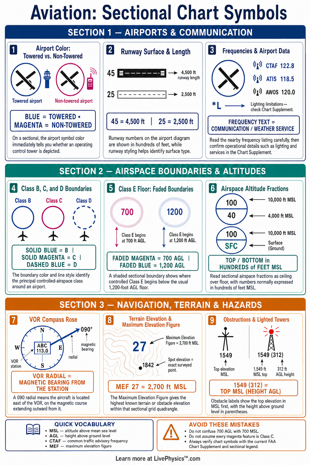
FAA sectional charts turn a large amount of flight information into a compact visual language. Pilots use these charts to plan routes, identify airports, avoid hazards, and understand airspace before and during a flight. This cheat sheet helps students recognize the most important symbols without getting lost in chart detail.
Key Facts
- A blue airport symbol usually identifies a public airport with an operating control tower, while a magenta airport symbol usually identifies a public airport without a control tower.
- A solid blue boundary identifies Class B airspace, and a solid magenta boundary identifies Class C airspace.
- A dashed blue boundary identifies Class D airspace, normally extending from the surface to the charted ceiling around a towered airport.
- A dashed magenta airspace boundary generally indicates Class E airspace beginning at 700 feet above ground level.
- A faded magenta airspace boundary generally indicates Class E airspace beginning at 1,200 feet above ground level.
- On an obstruction symbol, the first elevation number is the top elevation in feet mean sea level, and the number in parentheses is the height above ground level.
- A maximum elevation figure gives the highest known terrain or obstacle elevation in a chart quadrangle, expressed in hundreds and tens of feet mean sea level.
- A VOR compass rose shows magnetic direction information, and the variation value helps convert between true and magnetic courses.
Vocabulary
- Sectional chart
- A detailed aeronautical chart used mainly for visual flight rules navigation and flight planning.
- Mean sea level
- A standard altitude reference based on the average level of the ocean.
- Above ground level
- A height measured from the local surface directly below an aircraft or object.
- Class B airspace
- Controlled airspace that surrounds the nation’s busiest airports and requires an air traffic control clearance to enter.
- VOR
- A ground-based radio navigation facility that provides directional information to equipped aircraft.
- Maximum elevation figure
- A charted number that shows the highest known terrain or obstacle elevation within a defined chart area.
Common Mistakes to Avoid
- Confusing mean sea level with above ground level causes altitude errors because charted obstacle elevations and obstacle heights use different reference points.
- Assuming every blue airport symbol means fuel is available is wrong because the symbol primarily identifies a towered public airport, not guaranteed services.
- Reading only an airspace boundary and ignoring its printed altitude limits is wrong because the same airspace class can have different vertical floors and ceilings.
- Treating a maximum elevation figure as a precise route altitude is unsafe because it is a broad screening value rather than a complete obstacle-clearance plan.
- Using sectional chart frequencies without checking current publications is wrong because communication frequencies, airport services, and airspace details may change.
Practice Questions
- 1 A charted obstruction is labeled 1,540 with 420 in parentheses. State the obstruction top elevation in feet mean sea level and its height above ground level.
- 2 Class E airspace begins at 700 feet above ground level in an area where the terrain elevation is 850 feet mean sea level. Calculate the Class E floor in feet mean sea level.
- 3 Identify the airspace class represented by a solid magenta boundary and state the normal communication expectation before entering it.
- 4 Explain why a pilot should use both a maximum elevation figure and individual obstruction symbols when selecting a safe visual flight route.
Understanding Sectional Chart Symbols
A sectional chart is a visual map designed for pilots flying under visual flight rules. It combines ordinary geographic information with aviation-specific information. Roads, rivers, towns, railroads, and terrain help a pilot confirm position from the cockpit.
Aviation symbols add the information needed to make safe decisions. A pilot reads the chart before departure, then compares charted features with the outside view during flight.
Airport symbols provide quick information about the type of airport and its services. A blue airport symbol generally identifies a public airport with an operating control tower. A magenta airport symbol generally identifies a public airport without a control tower.
The runway drawing shows the approximate runway layout and surface type. Nearby text can include the airport name, elevation, runway length, lighting, fuel, frequency information, and communications notes. Pilots must check current publications because airport services and frequencies can change.
Airspace symbols are among the most important items on a sectional chart. Solid blue boundaries identify Class B airspace, which normally surrounds the busiest airports. Solid magenta boundaries identify Class C airspace.
Dashed blue boundaries identify Class D airspace around a towered airport. Dashed magenta shading usually shows Class E airspace beginning at 700 feet above ground level.
Faded magenta shading usually shows Class E airspace beginning at 1,200 feet above ground level. The numbers printed near an airspace boundary show vertical limits, so pilots must read both the boundary shape and the altitude information.
Obstructions and terrain require careful attention during route planning. Towers, antennas, wind turbines, and tall buildings can be marked with obstruction symbols. A number beside the symbol gives the elevation of the top of the obstruction above mean sea level.
A number in parentheses gives the height above ground level. Maximum elevation figures show the highest known elevation within a chart quadrangle and give a fast terrain screening tool. They do not replace detailed altitude planning, especially in mountainous areas or near tall obstacles.
Navigation aids and visual checkpoints help pilots follow a planned route. VOR facilities, airport identifiers, compass roses, and magnetic variation information support navigation planning. Prominent landmarks such as bridges, dams, power lines, and cities can help a pilot maintain situational awareness.
Special use airspace, including restricted areas, prohibited areas, military operations areas, and alert areas, has its own boundary patterns and labels. Students should practice reading the chart legend, matching each symbol to its meaning, and checking the altitude or frequency data connected to that symbol.