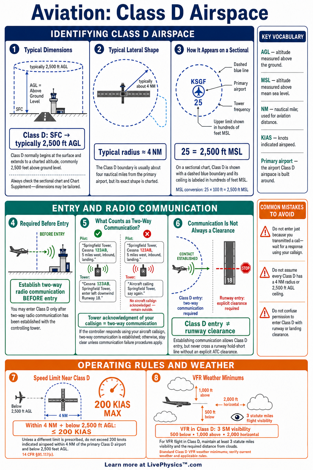
Class D airspace surrounds airports with an operating control tower and helps organize aircraft arriving, departing, and flying nearby. Pilots need this cheat sheet to recognize Class D on charts, communicate correctly, and follow the rules for entry. These procedures reduce conflict between aircraft in the busy airport environment.
They also help pilots work smoothly with air traffic control.
Class D airspace is usually shown by a dashed blue line on a sectional chart. It normally extends from the surface to about 2,500 feet above ground level, although its shape and ceiling can vary. Before entering, pilots establish two-way radio communication with the control tower.
Basic VFR weather minimums require three statute miles visibility and specified cloud clearances.
Key Facts
- Class D airspace normally surrounds an airport with an operating control tower.
- Class D airspace is shown on sectional charts by a dashed blue boundary line.
- Before entering Class D airspace, a pilot must establish two-way radio communication with the controlling tower.
- Two-way communication is established when the controller responds using the aircraft call sign.
- Basic VFR weather minimums in Class D are three statute miles visibility, 500 feet below clouds, 1,000 feet above clouds, and 2,000 feet horizontally from clouds.
- The usual Class D vertical limit is from the surface to 2,500 feet above ground level, but published dimensions may differ.
- A boxed number such as 30 on a sectional chart means the Class D ceiling is 3,000 feet mean sea level.
- When the tower is closed, Class D airspace may change to Class E or Class G airspace according to published information.
Vocabulary
- Class D airspace
- Controlled airspace around an airport with an operating control tower, usually extending from the surface to a published ceiling.
- Two-way radio communication
- An exchange in which air traffic control replies to a pilot using the aircraft call sign.
- Control tower
- An air traffic control facility that directs aircraft and vehicle movement at and near an airport.
- AGL
- Above ground level, which measures altitude from the surface directly below an aircraft.
- MSL
- Mean sea level, which is the standard reference level used for many charted altitudes.
- Chart Supplement
- An FAA publication containing airport details such as frequencies, tower hours, runway information, and local procedures.
Common Mistakes to Avoid
- Entering after hearing a general tower broadcast is incorrect because the controller must reply using the aircraft call sign to establish two-way communication.
- Treating Class D entry as requiring an explicit clearance is incorrect because two-way communication, not a clearance, is normally required before entry.
- Assuming every Class D area reaches 2,500 feet above ground level is incorrect because the ceiling and shape may be modified and must be checked on current charts.
- Using airport elevation instead of the charted Class D ceiling can cause an altitude error because many published ceiling numbers are expressed in mean sea level.
- Ignoring tower operating hours is unsafe because the airspace classification and radio procedure may change when the tower closes.
Practice Questions
- 1 A Class D area has a boxed 30 shown on the sectional chart. What is its published ceiling in feet mean sea level?
- 2 A VFR aircraft is flying in Class D airspace at 4,500 feet mean sea level. What is the minimum altitude it may fly below a cloud layer under basic VFR cloud clearance rules?
- 3 A pilot calls the tower with position and landing intentions, and the controller replies, "Aircraft calling, say again." May the pilot enter Class D airspace at this time?
- 4 Explain why a pilot should check tower operating hours before relying on Class D entry procedures.
Understanding Class D Airspace
Class D airspace is controlled airspace built around an airport that has an operating control tower. Its main job is to separate and sequence traffic near the airport. The tower controller gives instructions for runway use, traffic flow, and safe movement in the traffic pattern.
Class D may have a simple circular shape, but many areas have extensions or irregular boundaries. Pilots must read the chart carefully instead of assuming every Class D area is the same size.
On a sectional chart, the boundary is a dashed blue line. A boxed number near the symbol often shows the ceiling in hundreds of feet mean sea level. For example, a boxed 30 means the Class D ceiling is 3,000 feet mean sea level.
If no ceiling is shown, the airspace commonly extends to 2,500 feet above ground level. The Chart Supplement provides important details such as tower frequency, operating hours, runway data, and special procedures.
A pilot must establish two-way radio communication with the controlling tower before entering Class D airspace. This is different from receiving an explicit clearance. The pilot normally calls the tower with aircraft type, position, altitude, and intended landing or transit request.
The controller establishes two-way communication by replying with the aircraft call sign. A response that does not include the call sign does not authorize entry. The pilot should remain outside the boundary until proper communication is established.
For VFR flight in Class D, visibility must be at least three statute miles. The aircraft must remain 500 feet below clouds, 1,000 feet above clouds, and 2,000 feet horizontally from clouds. These limits give pilots time to see and avoid other aircraft.
They are especially important around airports because aircraft may be climbing, descending, turning, or operating at different speeds. Pilots should also listen closely for traffic advisories and runway instructions.
When the control tower closes, the airspace classification can change. Many Class D areas become Class E or Class G airspace, depending on the published design and time of day. The airport may still have active traffic, so pilots should use the published common traffic advisory frequency and follow normal non-towered airport procedures.
Careful preflight planning matters because tower hours, frequencies, and temporary restrictions can change. A strong study habit is to compare the sectional chart, Chart Supplement, airport diagram, and current notices before each flight.