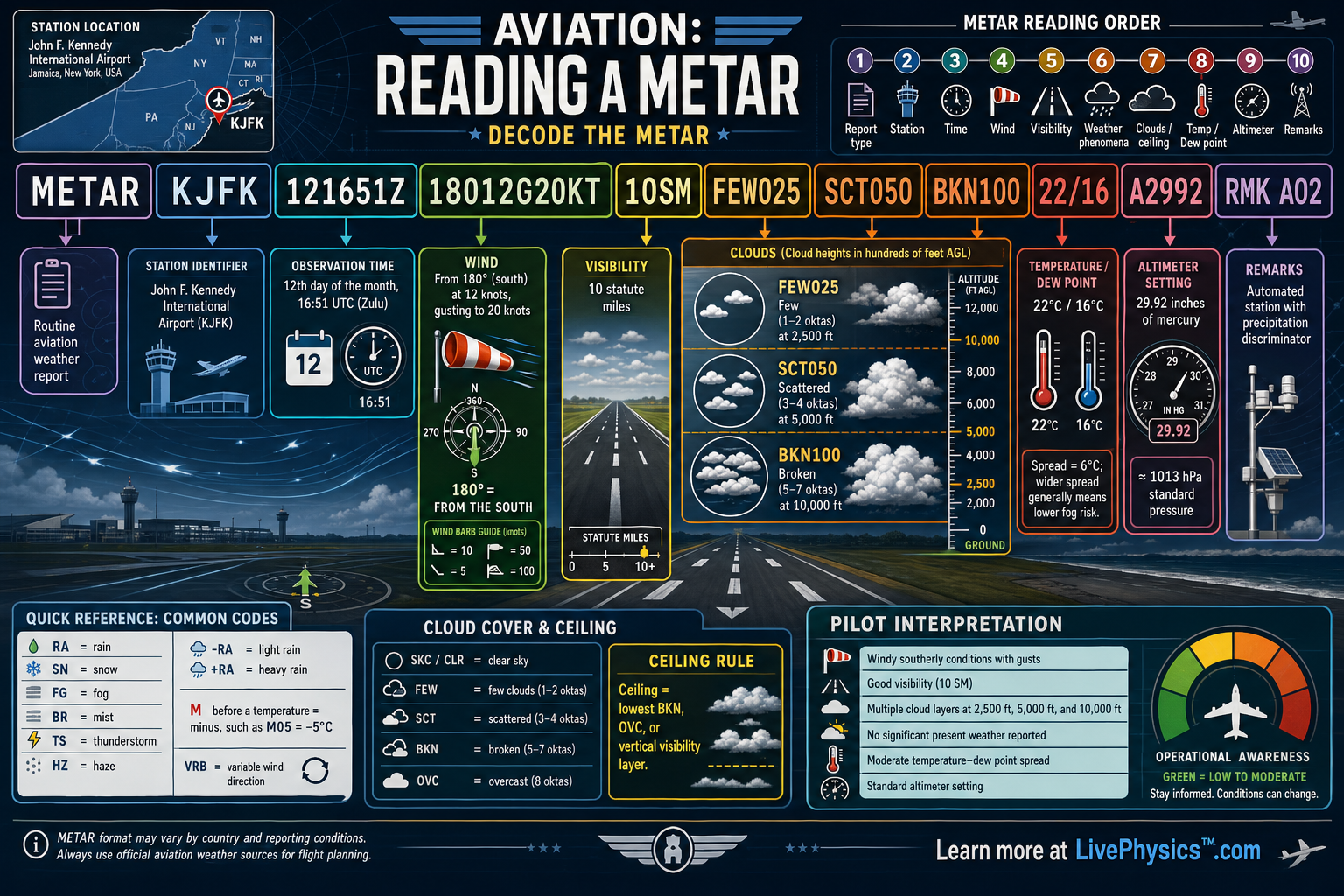
A METAR is a short coded weather report used by pilots, dispatchers, and air traffic services. It describes conditions at an airport at a specific time. Reading one quickly matters because wind, visibility, clouds, temperature, and pressure all affect flight decisions.
The code looks dense at first, but each group follows a standard order.
The sample report comes from John F. Kennedy International Airport in New York. It reports an observation made on the twelfth day of the month at 1651 UTC.
The wind is from the south at 12 knots, with gusts to 20 knots, and visibility is 10 statute miles. The report then gives cloud layers, temperature and dew point, altimeter setting, and an automated-station remark.
Understanding Aviation, Reading a METAR
METAR stands for Meteorological Aerodrome Report. Airports issue these observations regularly, often once each hour. Some stations issue special reports when weather changes quickly or reaches an important limit.
Every report begins with the station identifier. KJFK identifies John F. Kennedy International Airport.
The next group gives the observation time in Coordinated Universal Time, often called UTC or Zulu time. Pilots use UTC so reports from different time zones can be compared without confusion.
Wind appears early because it strongly affects runway selection and aircraft control. A group beginning with three digits gives the direction the wind comes from in degrees true. In the example, 180 means wind from the south.
The next two digits give steady wind speed in knots. The letter G followed by a number reports gusts.
Gusts are brief increases in wind speed. A pilot compares this wind with the runway heading to determine the headwind, tailwind, and crosswind components.
Visibility tells how far a person can see horizontal objects near the airport. In United States METAR reports, visibility is usually given in statute miles. Ten statute miles is generally good visibility, though pilots still need to consider clouds and precipitation.
Weather phenomena can appear after visibility. Codes may report rain, snow, fog, haze, thunderstorms, or other conditions.
A minus sign before a weather code means light intensity, while a plus sign means heavy intensity. No weather code in this sample means no significant present weather was observed.
Cloud groups describe both amount of sky covered and height above ground level. FEW means a small amount of cloud, SCT means scattered clouds, and BKN means broken clouds. The three digits after each cloud amount are hundreds of feet.
Therefore, FEW025 means a few clouds at 2,500 feet. SCT050 means scattered clouds at 5,000 feet. BKN100 means a broken layer at 10,000 feet.
The lowest broken or overcast layer is called the ceiling. Few and scattered layers do not create a ceiling.
The temperature and dew point group helps reveal humidity and possible cloud or fog development. The first value is air temperature in degrees Celsius. The second is dew point, the temperature at which air becomes saturated if cooled.
When these values are close, the air is humid and low clouds or fog become more likely. The altimeter group gives pressure for setting an aircraft altimeter. A2992 represents 29.92 inches of mercury.
Finally, RMK introduces remarks. AO2 means the automated station can detect precipitation types, which provides extra detail for weather observers and users.
Key Facts
- METAR = routine airport weather observation.
- 121651Z = observation on day 12 at 1651 UTC.
- 18012G20KT = wind from 180 degrees at 12 knots, gusting to 20 knots.
- 10SM = visibility of 10 statute miles.
- FEW025 SCT050 BKN100 = clouds at 2,500 feet, 5,000 feet, and 10,000 feet above ground level.
- 22/16 = temperature 22 degrees Celsius and dew point 16 degrees Celsius. A2992 = altimeter setting 29.92 inches of mercury.
Vocabulary
- METAR
- A standardized coded report of current weather conditions at an airport.
- UTC
- A worldwide time standard used in aviation so all weather reports use the same reference time.
- Dew point
- The temperature at which air becomes saturated and water vapor can begin to condense.
- Ceiling
- The height of the lowest broken or overcast cloud layer above the ground.
- Altimeter setting
- A pressure value that pilots set in an altimeter to obtain altitude relative to local sea level pressure.
Common Mistakes to Avoid
- Reading wind direction as the direction the wind is going. A wind direction of 180 degrees means the wind comes from the south and blows toward the north.
- Treating every cloud layer as a ceiling. Only the lowest broken or overcast layer defines the ceiling, while few and scattered layers do not.
- Reading cloud heights as exact feet. The three digits represent hundreds of feet, so 050 means 5,000 feet above ground level.
- Assuming temperature and dew point are measured in Fahrenheit. Standard METAR temperature and dew point values are reported in degrees Celsius.
Practice Questions
- 1 Decode the wind group 27015G24KT. State the wind direction, steady speed, and gust speed.
- 2 A METAR contains SCT035 BKN080 18/14 A3005. State the heights of both cloud layers, identify the ceiling, and give the temperature and dew point.
- 3 Explain why a pilot should pay close attention when the temperature and dew point in a METAR are only one or two degrees Celsius apart.