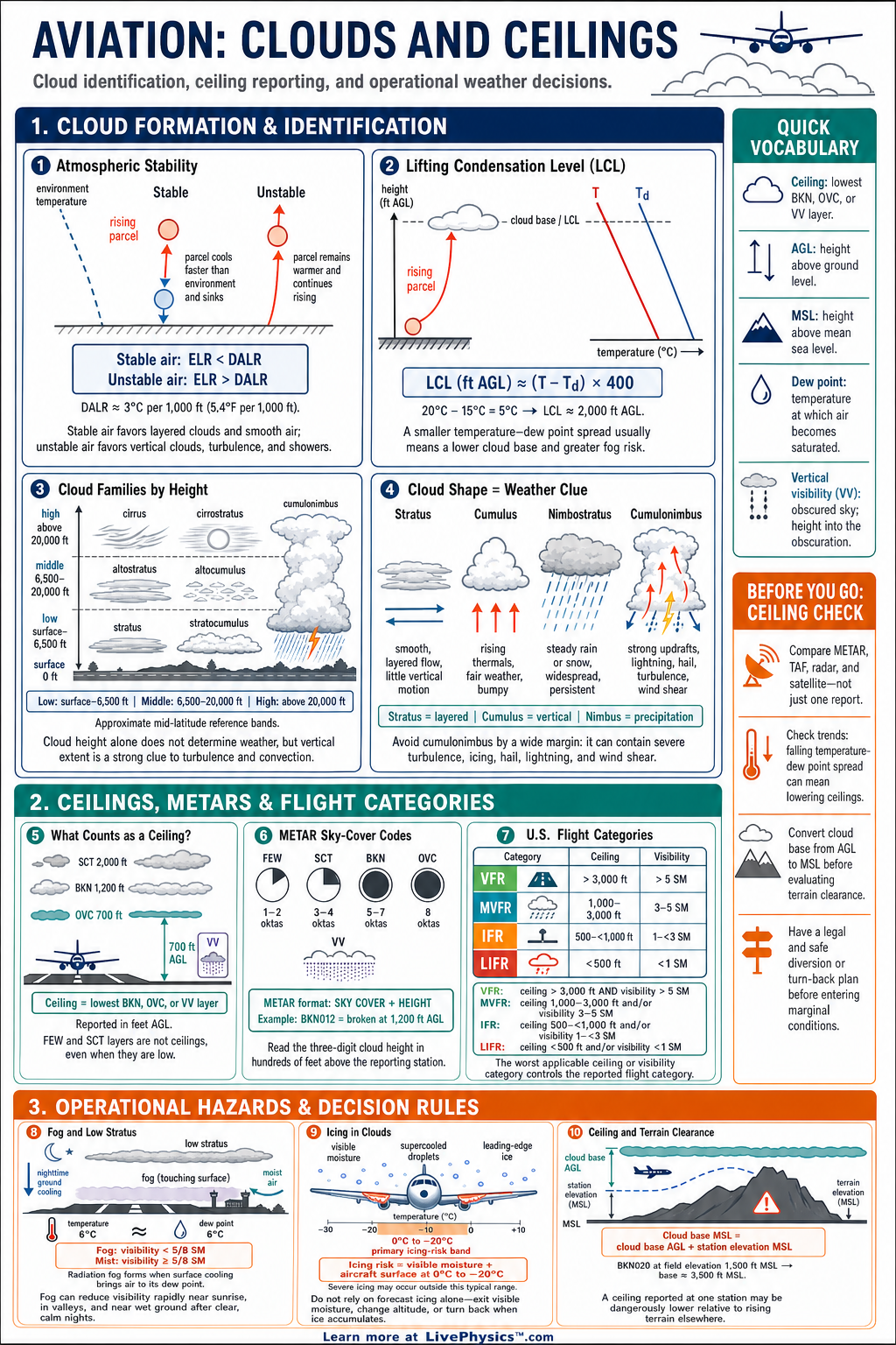
Clouds and ceilings affect route planning, fuel choices, takeoff decisions, and safe approaches. Pilots must identify cloud layers and understand how weather reports describe their height and coverage. This cheat sheet organizes the cloud information most often used in METARs, TAFs, and preflight weather briefings.
It helps aviation students connect observations outside the aircraft with operational limits.
A ceiling is the lowest broken layer, overcast layer, or vertical visibility into an obscuration. Sky cover is reported with standard abbreviations such as FEW, SCT, BKN, and OVC. Cloud heights in routine aviation reports are generally given in hundreds of feet above ground level.
A quick temperature and dew point calculation can also estimate the likely cloud base before a flight.
Key Facts
- A ceiling is the lowest broken layer, overcast layer, or vertical visibility into an obscuration.
- FEW means one eighth to two eighths sky cover, SCT means three eighths to four eighths, BKN means five eighths to seven eighths, and OVC means eight eighths.
- A cloud group such as BKN020 means a broken cloud layer at 2,000 feet above ground level.
- Cloud heights in standard METAR cloud groups are reported in hundreds of feet above ground level.
- The estimated cloud base in feet equals the temperature dew point spread in degrees Celsius divided by 2.5, then multiplied by 1,000.
- A scattered layer does not count as a ceiling, but a broken or overcast layer does count as a ceiling.
- VV003 means vertical visibility is 300 feet because an obscuration prevents a normal view of the sky.
Vocabulary
- Ceiling
- The lowest broken or overcast cloud layer, or vertical visibility into an obscuration, reported above ground level.
- METAR
- A METAR is a routine coded report of observed weather conditions at an airport.
- TAF
- A TAF is an airport forecast that predicts expected weather conditions over a stated time period.
- Dew point
- The dew point is the temperature at which air becomes saturated and condensation can begin.
- Vertical visibility
- Vertical visibility is the distance a person can see upward into an obscuration such as fog or heavy snow.
- Above ground level
- Above ground level is a height measured from the local surface directly below an aircraft or cloud.
Common Mistakes to Avoid
- Treating SCT as a ceiling is wrong because scattered clouds do not meet the broken or overcast coverage requirement for a ceiling.
- Reading BKN020 as 20,000 feet is wrong because the three digits in a METAR cloud group represent hundreds of feet, so BKN020 is 2,000 feet.
- Using a cloud-base estimate as an exact observation is wrong because weather patterns, terrain, and moisture changes can make the real base different.
- Confusing altitude with height above ground level is wrong because cloud reports use height above the local ground, not height above sea level.
- Looking only at the ceiling is incomplete because poor visibility, precipitation, wind, and convective activity can still make a flight unsafe.
Practice Questions
- 1 Decode the cloud group OVC012 and state whether it is a ceiling.
- 2 The temperature is 18 degrees Celsius and the dew point is 13 degrees Celsius. Estimate the cloud base above ground level using the temperature dew point spread method.
- 3 A METAR reports FEW025 SCT040 BKN070. Identify the ceiling and give its height above ground level.
- 4 Explain why a pilot should consider visibility and forecast trends along with a reported high ceiling before deciding that visual flight conditions are suitable.
Understanding Clouds and Ceilings
Clouds form when air cools to its dew point and water vapor condenses on tiny particles in the air. Rising air cools because pressure decreases with altitude. This process is common near fronts, mountains, and areas of daytime heating.
The type and height of the cloud give clues about the stability and moisture of the air mass. Layered clouds often occur in stable air, while puffy clouds usually indicate rising and less stable air.
Pilots describe cloud coverage by how much of the sky is covered. FEW means one eighth to two eighths coverage. SCT means three eighths to four eighths.
BKN means five eighths to seven eighths, and OVC means eight eighths. A scattered layer is not a ceiling, even if it is low. A broken or overcast layer becomes a ceiling because it can restrict a pilot's view of the ground or sky during visual flight.
METAR cloud groups combine a coverage code with a height. For example, BKN020 means a broken layer at 2,000 feet above ground level. OVC008 means an overcast layer at 800 feet above ground level.
When the sky is hidden by fog, snow, smoke, or another obscuration, a report can use vertical visibility. VV003 indicates that the observer can see vertically only to 300 feet. These details are especially important near airports because ceilings can change approach options and legal flight rules.
A useful planning estimate for cloud base uses the difference between air temperature and dew point. In Celsius, divide the temperature dew point spread by 2.5 and multiply by 1,000 feet. The result is an approximate cloud base above ground level.
For example, a temperature of 20 degrees Celsius and a dew point of 15 degrees Celsius give a spread of 5 degrees. The estimated cloud base is about 2,000 feet above ground level. This is only an estimate because local terrain, fronts, and changing moisture can alter the actual cloud height.
Study cloud reports together with visibility, wind, precipitation, and forecast trends. A high ceiling does not guarantee good flying weather if visibility is poor or thunderstorms are nearby. A low ceiling may force an instrument approach, a diversion, or a delayed departure.
Pilots should compare the reported ceiling with airport minimums, route terrain, and their own qualifications. Strong weather decisions come from using several sources rather than relying on one cloud observation.