Weather Fronts and Air Masses Explorer
Air masses bring their own temperature and moisture, and fronts form where two of them meet. Study cold, warm, stationary, and occluded fronts with simple cross sections, then quiz yourself on which front or air mass a description matches.
Study the reference cards first, then take a guided quiz with a hint on every question.
Air masses
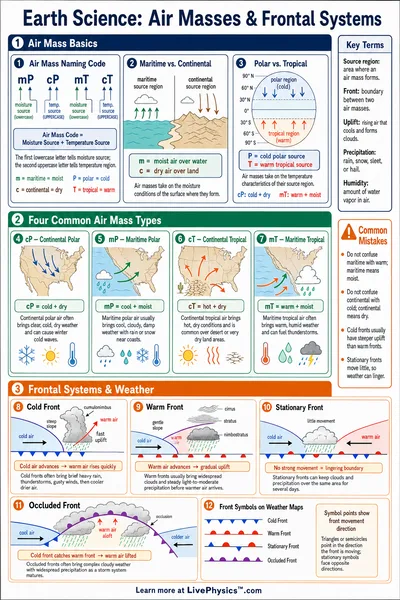
An air mass is a large body of air with a fairly uniform temperature and moisture. It is named for its source region. The first letter describes moisture and the second describes temperature.
Source. Northern Canada and high-latitude land
Cold and dry air that forms over cold land surfaces. In winter it brings clear, frigid weather to the central and eastern United States.
Source. Cold ocean waters of the North Pacific and North Atlantic
Cool and moist air that forms over cold oceans. It brings cloudy skies, fog, drizzle, and steady rain or snow to coastal regions.
Source. Deserts of the southwestern United States and northern Mexico
Hot and very dry air that forms over deserts in summer. It brings clear skies, intense heat, and drought conditions.
Source. Warm ocean waters of the Gulf of Mexico, Caribbean, and tropical Atlantic
Warm and very moist air that forms over warm oceans. It supplies the humidity and energy for thunderstorms and heavy rain in summer.
Source. Arctic Ocean ice and the far northern polar region
Bitterly cold and extremely dry air from the high Arctic. It is colder than continental polar air and drives severe cold outbreaks in winter.
Fronts
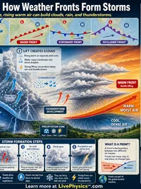
A front is the boundary where two different air masses meet. Pick a front to see what is happening, its map symbol, the cloud sequence, and the weather it brings.
Map symbol. A blue line with solid triangles pointing in the direction the front is moving.
Cold Front
- What is happening
- Cold, dense air advances and pushes under the warm air ahead of it.
- Slope
- Steep slope, which forces warm air to rise quickly.
- Clouds
- Towering cumulus and cumulonimbus storm clouds along a narrow band.
- Weather it brings
- Brief but intense weather. Heavy showers, thunderstorms, gusty winds, and a sharp temperature drop, followed by clearing and cooler, drier air.
Reference Guide
Air Masses
An air mass is a large body of air with a fairly uniform temperature and moisture content. It takes on the character of its source region as it sits there for days.
Air masses are named with two letters. The first letter is moisture, where c means continental (dry, formed over land) and m means maritime (humid, formed over water). The second letter is temperature, where P means polar (cold), T means tropical (warm), and A means Arctic (bitterly cold).
- cP continental polar. Cold and dry from northern land.
- mP maritime polar. Cool and humid from cold oceans.
- cT continental tropical. Hot and dry from deserts.
- mT maritime tropical. Warm and humid from warm oceans.
- A Arctic. Bitterly cold and very dry from the high Arctic.
The Four Fronts
A front is the boundary where two air masses with different temperatures meet. The type of front depends on which air mass is advancing and how steeply the warm air is lifted.
- Cold front. Cold dense air wedges under warm air with a steep slope, giving brief heavy storms then clearing.
- Warm front. Warm air glides gently up over retreating cold air, giving a long, steady, light rain.
- Stationary front. Neither air mass moves, so the boundary stalls and brings days of clouds and light rain.
- Occluded front. A cold front overtakes a warm front and lifts the warm air off the ground as a storm matures.
Cloud Sequence and Symbols
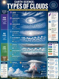
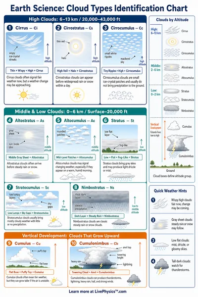
A warm front announces itself with an orderly cloud sequence. High wispy cirrus thicken into cirrostratus and altostratus, then lower into thick nimbostratus as the steady rain arrives.
A cold front instead lines up towering cumulonimbus storm clouds in a narrow band, so the weather is intense but short lived.
On a weather map a cold front is a blue line with triangles, a warm front is a red line with half circles, a stationary front alternates triangles and half circles in opposite directions, and an occluded front is a purple line with both symbols together.
How to Use This Tool
Start in Reference view. Read the air mass cards, then pick a front to see its cross section, map symbol, clouds, and weather.
- Pick Learn, Practice, or Challenge to set the quiz difficulty.
- Learn shows a hint on every question, Challenge mixes question types.
- Switch to Quiz, read the description, and choose the matching answer.
- Check your answer to reveal the explanation and update your score.
- Use Share view to copy a link to the current mode and front.
Every quiz question explains why the answer is correct, so a wrong guess still teaches the underlying idea.