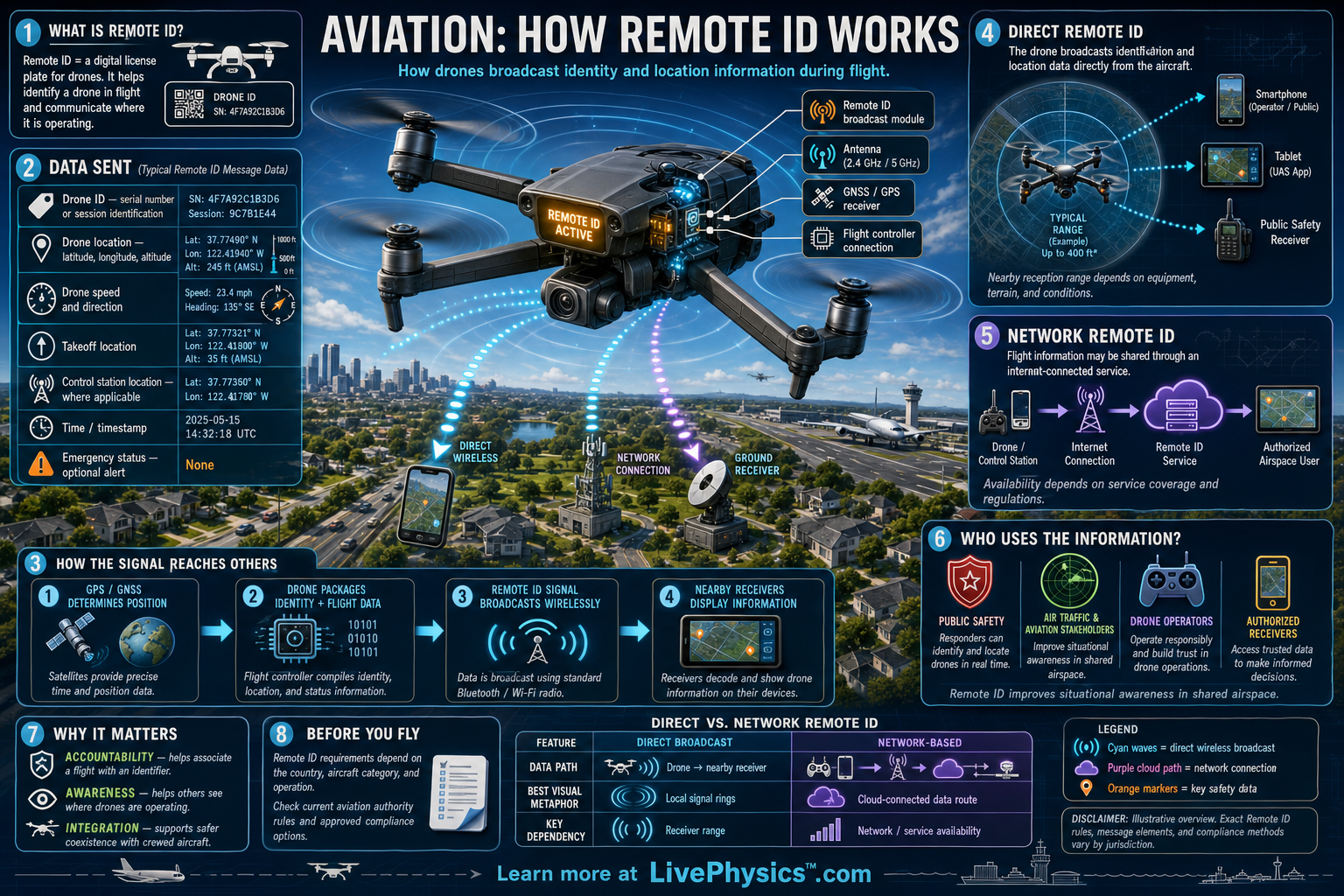
Remote ID gives many drones a way to identify themselves while they fly. It is often compared with a digital license plate because nearby people and authorized systems can receive information about the aircraft. This improves airspace awareness as drones share the sky with helicopters, airplanes, emergency crews, and other drones.
It matters most when a drone is operating beyond the view of people on the ground or near busy airspace.
A Remote ID capable drone sends radio messages during flight through a broadcast signal. The message can include the drone's identification, position, altitude, speed, control-station location, and a time mark. A phone, tablet, dedicated receiver, or ground station can decode the signal when it is within range and supports the correct standard.
In the United States, Remote ID rules set by the Federal Aviation Administration apply to many drones that must be registered.
Understanding Aviation, How Remote ID Works
Remote ID is a system for making a drone more visible to people and systems nearby. It does not control the drone and it does not prevent every unsafe flight. Instead, it sends a small set of data messages over radio signals while the drone is operating.
Think of it as an electronic identification beacon. The messages help observers connect an aircraft in the sky with useful flight information. This supports safer decisions when several aircraft may be using the same area.
In the United States, a drone can usually meet the Federal Aviation Administration Remote ID requirement in one of three ways. A Standard Remote ID drone has the equipment built into the aircraft by its manufacturer. A Remote ID broadcast module can be attached to a drone that lacks built in capability.
The third option is flying without Remote ID inside a Federal Aviation Administration Recognized Identification Area, often called a FRIA. A drone using an attached module must generally remain within visual line of sight because the module broadcasts the location of the takeoff point rather than the current location of the person controlling it.
During a flight, the Remote ID transmitter sends repeated packets of information. These packets commonly report a session identification, the drone latitude and longitude, geometric altitude, velocity, and an emergency status when applicable. They report the location of the control station or takeoff point, depending on the compliance method.
The signal includes a time mark so a receiver can tell how recent the information is. Radio range depends on power, antenna design, buildings, hills, trees, interference, and the receiver. A receiver that is too far away may miss packets even when the drone is transmitting correctly.
Remote ID data is meant for local awareness, not for public access to every detail about a pilot. The identifier received over the air is not simply the pilot's name or home address. Authorized officials can use the identifier with registration records when they need to investigate an operation.
A member of the public may see a drone position through a compatible receiving device, yet access to personal registration data remains controlled. Operators should understand that Remote ID does not replace normal flight rules such as visual line of sight, airspace authorization, altitude limits, or yielding to crewed aircraft.
Students can connect Remote ID to ideas from physics, computing, and communications. The drone uses electrical energy to power sensors, navigation hardware, a processor, and a radio transmitter. GPS or similar satellite navigation provides location and timing data, while the onboard controller packages that data for broadcast.
Focus on the difference between transmitting information and receiving it. Focus too on the limits of any measurement, since a reported location has uncertainty and can be delayed. Remote ID works best as one layer in a larger system of responsible flying, clear rules, trained operators, and airspace coordination.
Key Facts
- Remote ID functions like a digital license plate by broadcasting identification and flight information from a drone.
- Standard Remote ID is built into a drone, while a broadcast module can add Remote ID capability to an older aircraft.
- Common broadcast data include an identifier, drone position, altitude, velocity, time mark, and control-station or takeoff location.
- In the United States, a drone operating under a Remote ID broadcast module generally must stay within visual line of sight.
- Radio signal strength decreases with distance, obstacles, antenna orientation, and electromagnetic interference.
- speed = distance / time
Vocabulary
- Remote ID
- A system that broadcasts identification and location-related information from a drone while it is flying.
- Broadcast module
- A device attached to a drone to transmit Remote ID information when the drone does not have built-in Remote ID.
- Control station
- The location of the person or equipment used to control a drone.
- FRIA
- A Federal Aviation Administration Recognized Identification Area where drones may fly without broadcasting Remote ID under specified conditions.
- Geometric altitude
- An altitude value based on a reference model of Earth rather than the height above the ground directly below the drone.
Common Mistakes to Avoid
- Assuming Remote ID is a tracking system that physically controls the drone. Remote ID broadcasts data, but it does not steer the aircraft or automatically stop a rule violation.
- Thinking every smartphone can receive every Remote ID signal. A device needs compatible radio hardware or a suitable receiver and software, and it must be within usable range.
- Treating Remote ID compliance as permission to fly anywhere. Operators still must follow airspace restrictions, registration rules, visual line of sight requirements, and other applicable rules.
- Mounting a broadcast module where its antenna or signal is blocked by the drone frame or battery. Poor placement can reduce signal reliability, so follow the module manufacturer instructions.
Practice Questions
- 1 A drone flies 600 meters in 75 seconds. Calculate its average speed in meters per second.
- 2 A Remote ID receiver records a drone at 120 meters altitude and then at 95 meters altitude. Calculate the change in altitude in meters.
- 3 Explain why Remote ID information alone does not prove that a drone flight is safe or authorized.