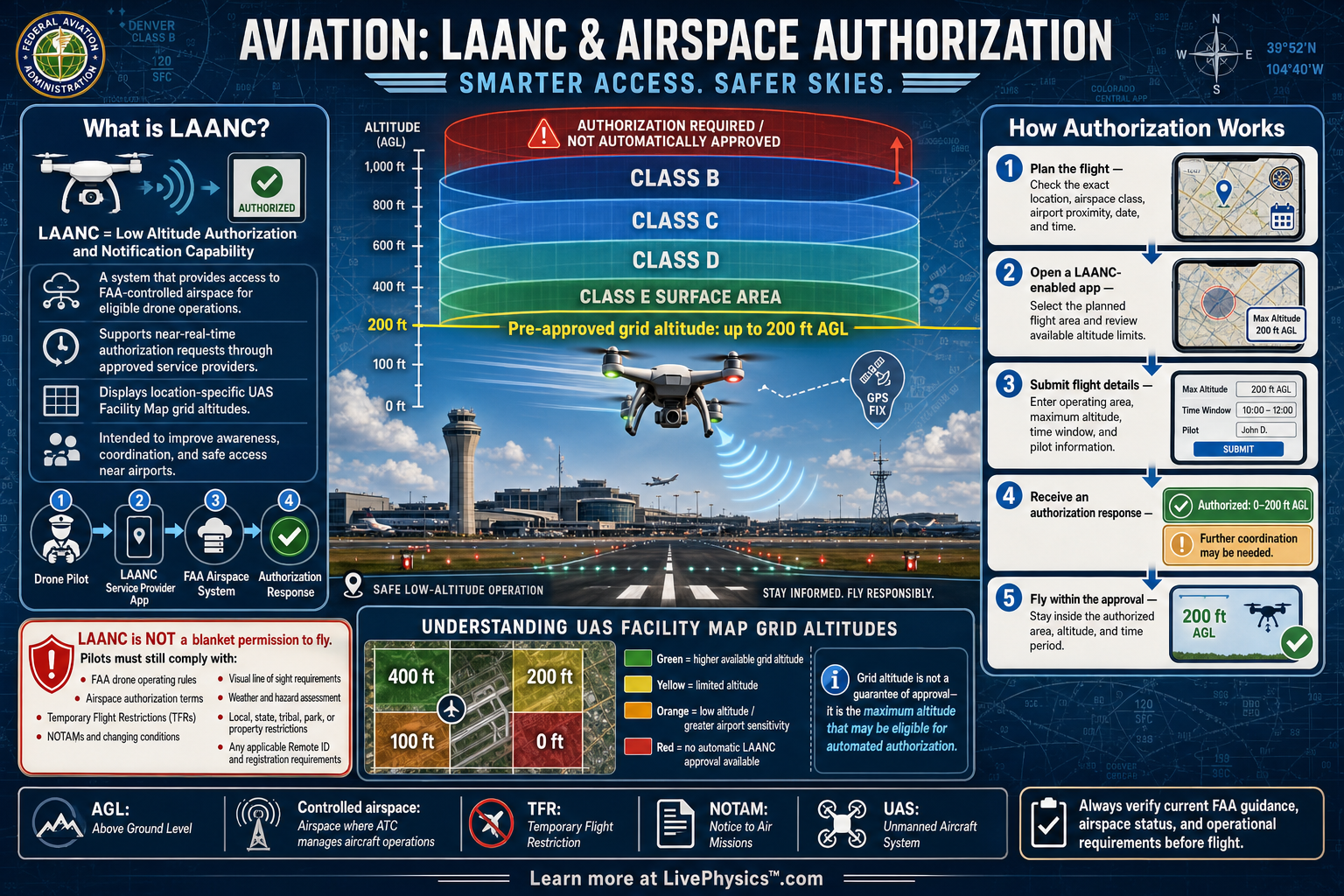
LAANC, short for Low Altitude Authorization and Notification Capability, is an FAA system that helps drone pilots request permission to fly in controlled airspace. Controlled airspace surrounds many airports, where aircraft may arrive, depart, or practice maneuvers at low altitude. A quick authorization process supports safer sharing of the sky.
It matters because a drone can create a serious hazard when flown near crewed aircraft without coordination.
Pilots use an FAA-approved LAANC service to submit a planned flight location, time, altitude, and other details. Many requests within published altitude limits can receive near-real-time approval. Requests above those limits may require further FAA review through the same system.
Authorization is one part of legal drone flight, so pilots still need to check weather, temporary flight restrictions, local rules, and operating requirements.
Understanding Aviation, LAANC and Airspace Authorization
Airspace is organized so air traffic controllers can manage aircraft safely. Around busy airports, controlled airspace often begins at the surface and extends upward. It may be Class B, Class C, Class D, or a designated section of Class E airspace.
Drone pilots generally need FAA authorization before flying in these areas. LAANC provides a practical digital path for requesting that authorization. It does not remove the pilot's responsibility to understand where the aircraft will fly.
LAANC relies on UAS Facility Maps, which divide the area around an airport into small grid sections. Each grid has a published maximum altitude for routine drone authorization. A grid close to a runway may show zero feet because crewed aircraft operate very low there.
A more distant grid may allow a higher altitude. These values reflect nearby flight paths, terrain, obstacles, and controller needs. The values are not a blanket permission to fly at any time.
A pilot enters the planned operation in an FAA-approved LAANC provider app. Important details include the launch point, operating altitude, date, time window, and flight area. If the request stays within a grid limit and meets system conditions, an automated authorization can arrive quickly.
If the request exceeds the published limit, the FAA may review it manually. The pilot should receive authorization before launch, then keep a copy available during the operation.
Authorization addresses controlled airspace, not every rule that applies to a flight. A pilot must still stay within the authorized altitude and location. Under many routine drone rules, the general maximum altitude is 400 feet above ground level, though special limits can apply.
The pilot must yield to crewed aircraft and avoid dangerous operations. Temporary flight restrictions can close airspace for emergencies, major events, wildfire response, or security activity. A previously approved authorization does not override a later restriction.
Students often meet this topic when planning aerial photography, surveying a construction site, inspecting infrastructure, or flying a school drone project. Start by identifying the airport and airspace class on an approved aviation map. Next, compare the launch location with the UAS Facility Map grid value.
Learn the difference between altitude above ground level and altitude above mean sea level. Careful location and altitude planning makes an authorization request accurate and keeps the flight predictable for everyone using the airspace.
Key Facts
- LAANC = Low Altitude Authorization and Notification Capability.
- FAA authorization is generally required before drone flight in controlled Class B, Class C, Class D, and designated Class E airspace.
- UAS Facility Maps show maximum routine authorization altitudes in grid sections near airports.
- Altitude MSL = altitude AGL + ground elevation MSL.
- Altitude AGL = altitude MSL - ground elevation MSL.
- 400 ft AGL is the general maximum altitude for many routine drone operations, subject to applicable exceptions and authorization limits.
Vocabulary
- LAANC
- An FAA system that provides drone airspace authorization requests through approved service providers.
- Controlled airspace
- Airspace where air traffic control manages aircraft operations and drone flights may need FAA authorization.
- UAS Facility Map
- An FAA map that shows grid-based maximum altitudes for routine drone authorizations near airports.
- AGL
- Above ground level, a height measurement taken from the surface directly below the aircraft.
- Temporary flight restriction
- A temporary FAA restriction that limits aircraft operations in a specific area for safety or security.
Common Mistakes to Avoid
- Assuming a LAANC authorization permits flight everywhere near an airport. Authorization applies only to the approved location, time window, and altitude, so compare the actual flight area with the request.
- Treating a UAS Facility Map grid altitude as a required flight altitude. The number is a maximum routine authorization value, and pilots should use only the altitude needed for the operation.
- Measuring altitude from sea level when the authorization limit is stated above ground level. Check local ground elevation so the drone remains below the allowed AGL altitude.
- Ignoring temporary flight restrictions after receiving authorization. Check FAA notices close to launch because a new restriction can prevent the planned flight.
Practice Questions
- 1 A UAS Facility Map grid permits routine authorization up to 100 feet AGL. A pilot plans to fly at 125 feet AGL in that grid. Determine how many feet above the grid limit the request is.
- 2 A drone is flying at 680 feet MSL over ground with an elevation of 525 feet MSL. Calculate the drone altitude in feet AGL.
- 3 A pilot has a LAANC authorization for 200 feet AGL near an airport, then notices a temporary flight restriction covering the area before launch. Explain the correct decision and the safety reason for it.