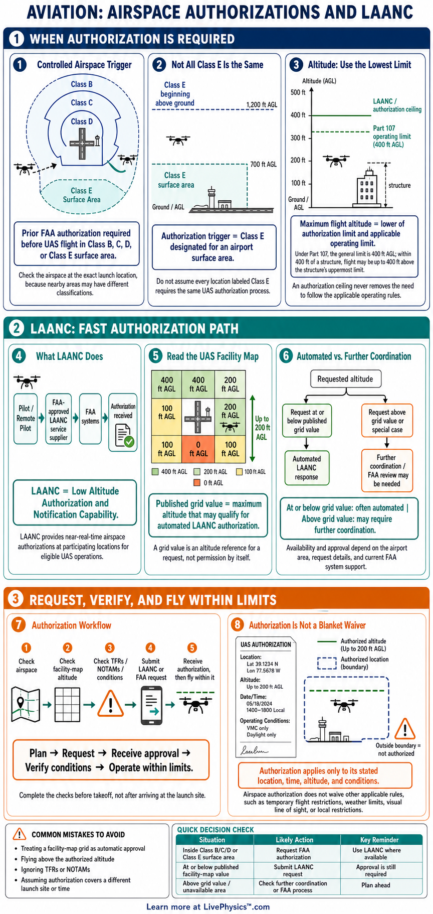
This cheat sheet explains when drone pilots need FAA airspace authorization and how LAANC helps obtain it. It is designed for Part 107 pilots, recreational flyers, and students planning lawful flights near airports. Use it to identify controlled airspace, choose an appropriate altitude, and understand what an approval allows.
LAANC stands for Low Altitude Authorization and Notification Capability. It provides near real-time authorization for many flights in controlled airspace at approved altitudes. UAS Facility Maps show the maximum altitude that may qualify for automatic approval in a specific grid.
An authorization is only one part of safe flight planning, since pilots must still follow all other FAA operating rules.
Key Facts
- Under Part 107 section 107.41, a pilot must have prior FAA authorization to operate a small unmanned aircraft in Class B, Class C, Class D, or surface Class E airspace.
- A LAANC request must state the operation area, date, time window, and maximum altitude above ground level.
- For automated LAANC approval, the requested maximum altitude must be less than or equal to the published UAS Facility Map grid altitude.
- The normal Part 107 altitude rule is 400 feet above ground level, unless flying within 400 feet of a structure and not higher than 400 feet above that structure.
- An airspace authorization applies only to its approved location, altitude, time period, and listed operating conditions.
- Recreational flyers must receive authorization before operating in controlled airspace under the recreational exception.
- A LAANC authorization does not authorize flight through a temporary flight restriction, restricted area, prohibited area, or hazardous condition.
Vocabulary
- Airspace authorization
- Airspace authorization is FAA permission to operate a drone in specified controlled airspace under stated conditions.
- LAANC
- LAANC is an FAA system that provides automated or coordinated drone airspace authorization requests through approved service suppliers.
- Controlled airspace
- Controlled airspace is airspace where the FAA manages aircraft traffic and drone operations may require prior authorization.
- UAS Facility Map
- A UAS Facility Map shows maximum altitudes that may be available for automated drone authorization in grids near airports.
- AGL
- AGL means above ground level, which measures altitude from the surface directly below the aircraft.
- NOTAM
- A NOTAM is a Notice to Air Missions that gives pilots current information about hazards, restrictions, or changes affecting flight.
Common Mistakes to Avoid
- Assuming every location near an airport needs the same approval is wrong because controlled airspace boundaries and UAS Facility Map grid altitudes vary by location.
- Requesting an altitude above the UAS Facility Map grid for an automatic LAANC approval is wrong because automated approval is limited to the published grid altitude.
- Treating a LAANC authorization as permission to ignore a temporary flight restriction is wrong because separate restrictions can still prohibit the flight.
- Flying outside the approved time window is wrong because an authorization is valid only during the date and time period shown in the approval.
- Measuring height from a launch point instead of local ground is wrong because approved and regulatory altitudes are measured above ground level.
Practice Questions
- 1 A UAS Facility Map grid shows 200 feet AGL. Can a pilot request automated LAANC authorization for a flight at 180 feet AGL?
- 2 A pilot receives authorization for a maximum altitude of 100 feet AGL but plans to inspect a 125-foot building. What maximum altitude may the pilot fly under that authorization?
- 3 An authorization is valid from 1:00 PM to 3:00 PM. If a mission begins at 2:40 PM and lasts 35 minutes, how many minutes of the mission fall outside the authorization window?
- 4 Explain why a pilot must check NOTAMs and temporary flight restrictions even after receiving a LAANC authorization.
Understanding Airspace Authorizations and LAANC
Airspace authorization is the FAA permission needed before a drone operation enters certain controlled airspace. In the United States, this usually means Class B, Class C, Class D, or surface Class E airspace around an airport. The authorization names the area, time, altitude, and other conditions that apply to the flight.
It is separate from a pilot certificate, aircraft registration, and any permission from a property owner. A pilot must identify the airspace at the planned location instead of relying only on how close the drone is to an airport.
LAANC means Low Altitude Authorization and Notification Capability. It connects approved FAA systems with drone service suppliers, allowing many requests to receive an automated decision within seconds. A pilot enters the planned flight area, date and time, and maximum altitude above ground level.
If the request fits a published UAS Facility Map altitude and the system conditions, LAANC can issue an authorization. Requests above the automatic grid altitude or involving special circumstances may need further coordination through LAANC or the FAA DroneZone.
UAS Facility Maps divide areas near airports into small grids. Each grid shows the maximum altitude that may be available for an automated authorization, often from zero to 400 feet above ground level. The number is not a guarantee that every request will be approved, and it is not a general operating altitude for flights without authorization.
It reflects how much altitude may be safely available near aircraft traffic. A pilot plans the highest point of the operation, including terrain, buildings, and the drone's height above local ground. The request must stay at or below the approved ceiling.
An authorization does not remove other FAA rules. Part 107 pilots must still keep visual line of sight, yield to manned aircraft, follow Remote ID requirements when applicable, and obey the normal altitude limit. Recreational flyers also need authorization before flying in controlled airspace, even though they operate under a different legal exception.
LAANC does not clear a flight through a temporary flight restriction, a restricted area, a prohibited area, or every local hazard. Before takeoff, pilots check current airspace information, NOTAMs, weather, and the authorization details. They also follow any special instructions shown in the approval.
Study this topic as a flight planning sequence. First locate the operation on an FAA approved airspace source and identify the airspace class at the surface. Next read the UAS Facility Map grid, choose a safe maximum altitude, and request authorization early enough for the planned time.
Save the authorization and make sure the actual flight remains inside its approved area and time window. This process matters during roof inspections, photography, construction work, emergency support, and school projects near airports. Good planning protects crewed aircraft and helps drone pilots make reliable, lawful decisions.