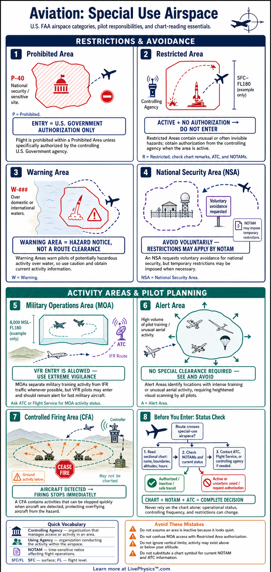
Special use airspace identifies areas where aviation activities may create hazards, require authorization, or call for extra vigilance. Pilots must recognize each type on charts and understand the operating rules before flight. This cheat sheet organizes the major FAA special use airspace categories into clear operational guidance.
It supports flight planning, chart interpretation, and practical test preparation.
The main categories are prohibited areas, restricted areas, warning areas, military operations areas, alert areas, and controlled firing areas. Each category has a different purpose, location, and entry requirement. A sectional chart, the Chart Supplement, NOTAMs, and ATC are important sources of current information.
Safe pilots plan for these areas early and maintain awareness as conditions change.
Key Facts
- A prohibited area may not be entered without permission from the controlling agency.
- An active restricted area requires authorization from the controlling or using agency before entry.
- A restricted area shown from the surface to 10,000 feet includes all altitudes from ground level through 10,000 feet.
- Warning areas begin at 3 nautical miles offshore and warn of activity that may be hazardous to nonparticipating aircraft.
- VFR pilots may enter a military operations area, but they should exercise extreme caution and contact the controlling agency for traffic advisories.
- An alert area does not restrict entry, and all participating and nonparticipating pilots are equally responsible for collision avoidance.
- Controlled firing area activity must stop when a spotter detects an aircraft that could be endangered.
Vocabulary
- Special use airspace
- Airspace where certain activities occur or where limits are imposed on aircraft operations for safety or security.
- Prohibited area
- An area in which flight is forbidden unless the controlling agency grants permission.
- Restricted area
- An area containing unusual or hazardous activities where entry may require authorization when the area is active.
- Warning area
- Airspace beyond the United States coast that warns pilots about potentially hazardous activity.
- Military operations area
- Airspace established to separate military training activities from IFR traffic.
- Controlling agency
- The agency that provides information, authorization, or separation services for a particular special use airspace area.
Common Mistakes to Avoid
- Treating every special use airspace area as closed airspace is wrong because alert areas, warning areas, and many MOAs do not automatically prohibit entry.
- Entering an active restricted area without authorization is wrong because hazardous activity may be taking place inside the published boundaries.
- Ignoring vertical limits is wrong because an aircraft can avoid an area by altitude only when its planned altitude is clearly outside the published floor and ceiling.
- Assuming a MOA is inactive because no military aircraft are visible is wrong because fast-moving training aircraft may be difficult to see and the area may still be active.
- Using an old chart or skipping NOTAMs is wrong because times of use, controlling agencies, and temporary restrictions can change.
Practice Questions
- 1 A restricted area extends from the surface to 8,000 feet MSL and is active. At what minimum altitude can a pilot overfly it without entering the restricted area if terrain and airspace rules permit?
- 2 A warning area starts 3 nautical miles offshore. How far from the United States coast does its inner boundary begin?
- 3 A VFR pilot plans to cross an active military operations area. List two actions that improve safety before and during the crossing.
- 4 Explain why a controlled firing area is not depicted on an aeronautical chart even though it may involve hazardous projectiles.
Understanding Special Use Airspace
Special use airspace is established to separate or warn pilots about unusual activities. Some areas contain operations that could be dangerous to nonparticipating aircraft. Others protect national security, support military training, or identify places with heavy pilot training activity.
The chart symbol alone is not enough to make a safe decision. Pilots need to identify the area type, its vertical limits, its operating times, and its controlling agency. They also need to check whether an area is active before departure and again when conditions make that necessary.
Prohibited areas are the most restrictive category. Flight is not allowed inside them without permission from the controlling agency. They are established for national welfare and security reasons.
Restricted areas contain activities that may be hazardous, such as artillery firing, aerial gunnery, guided missiles, or testing. A pilot may enter an inactive restricted area without prior permission, but must obtain authorization from the controlling agency when the area is active. ATC can provide status information and route aircraft around an active area when needed.
Warning areas extend from three nautical miles outward from the United States coast and may reach international airspace. They warn pilots about activity that can be hazardous, but they do not automatically prohibit entry. Military operations areas separate certain military training from instrument flight rules traffic.
Visual flight rules pilots may enter a military operations area, but should use extreme caution and contact the controlling agency for traffic information. Alert areas mark locations with high volumes of training, parachute activity, glider operations, or similar activity. All pilots share responsibility for seeing and avoiding other aircraft there.
Controlled firing areas support activities that could involve hazardous projectiles. Unlike other special use airspace, they are not shown on aeronautical charts because the activity stops when a spotter sees an aircraft approaching. This arrangement reduces the hazard to aircraft while allowing the activity to continue when the sky is clear.
During flight planning, study the chart boundaries and altitude limits carefully. A limit from the surface to ten thousand feet means the area includes every altitude in that range. Record frequencies and hours, review NOTAMs, and build alternate routes that avoid active areas when practical.