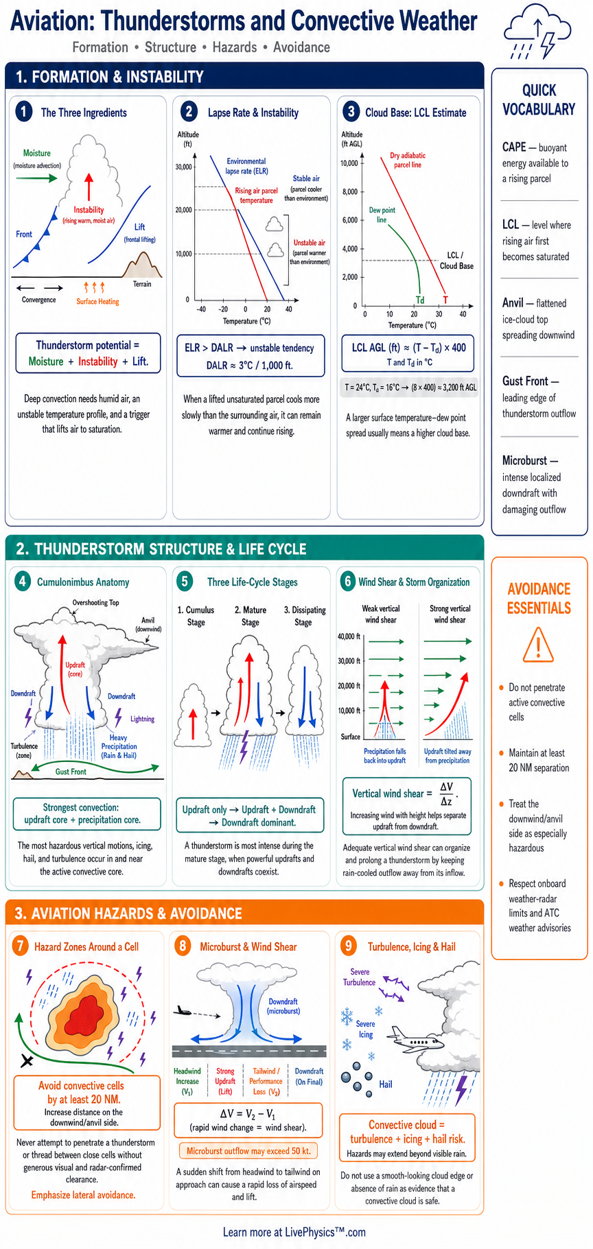
Thunderstorms are among the most serious weather hazards for pilots because they can produce severe turbulence, icing, hail, lightning, wind shear, and heavy rain. This cheat sheet explains how convective weather forms and how pilots identify its risks. It supports weather briefing, flight planning, and safe operational decisions.
Students can use it to connect atmospheric theory with practical aviation hazards.
Convection begins when warm, moist air rises and cools to its dew point. Atmospheric stability, moisture, lift, and wind shear control whether clouds grow into thunderstorms. The three main thunderstorm stages are cumulus, mature, and dissipating.
Pilots must recognize that every thunderstorm stage can be hazardous and that visual, radar, and forecast information must be used together.
Key Facts
- A thunderstorm requires moisture, instability, and a lifting mechanism.
- The environmental lapse rate equals the decrease in surrounding air temperature with increasing altitude.
- Unsaturated rising air cools at about 3 degrees Celsius per 1,000 feet, called the dry adiabatic lapse rate.
- Saturated rising air cools at about 1.5 to 2 degrees Celsius per 1,000 feet, called the moist adiabatic lapse rate.
- A parcel is unstable when it is warmer and less dense than the surrounding air, so it continues to rise.
- The mature thunderstorm stage contains both updrafts and downdrafts and produces the most severe combined hazards.
- A pilot should avoid a thunderstorm by at least 20 nautical miles when possible and should never attempt to fly through a cell.
- Cloud base height in feet above ground level can be estimated as temperature minus dew point, divided by 2.5, times 1,000.
Vocabulary
- Convection
- Convection is the vertical movement of air caused by differences in temperature and density.
- Cumulonimbus
- A cumulonimbus cloud is a tall thunderstorm cloud that can produce lightning, hail, heavy rain, and severe turbulence.
- Atmospheric stability
- Atmospheric stability describes how strongly the atmosphere resists or supports vertical air movement.
- Updraft
- An updraft is a rising current of air that can carry moisture, cloud droplets, and aircraft upward.
- Microburst
- A microburst is a strong localized downdraft that creates damaging and rapidly changing winds near the ground.
- Wind shear
- Wind shear is a significant change in wind speed or direction over a short horizontal or vertical distance.
Common Mistakes to Avoid
- Assuming the dissipating stage is safe is wrong because downdrafts, turbulence, lightning, icing, and wind shear can remain dangerous after rainfall weakens.
- Flying between two nearby thunderstorm cells is risky because cells can grow, merge, or create severe turbulence and hail in the apparent gap.
- Treating airborne weather radar as a complete hazard detector is wrong because radar mainly detects precipitation and may not show turbulence, lightning, or all wind shear.
- Using a close visual estimate of a storm's distance is unreliable because large clouds can hide their true size and may produce hazards far from visible rain.
- Descending beneath an anvil to avoid the main cloud is unsafe because hail, lightning, turbulence, and strong outflow winds can extend well beyond the rain shaft.
Practice Questions
- 1 The surface temperature is 25 degrees Celsius and the dew point is 15 degrees Celsius. Estimate the cloud base height above ground level using the temperature dew point spread rule.
- 2 An unsaturated air parcel begins at 24 degrees Celsius and rises 4,000 feet. Using a dry adiabatic lapse rate of 3 degrees Celsius per 1,000 feet, calculate its temperature at 4,000 feet.
- 3 A pilot observes a developing towering cumulus cloud ahead, a cold front nearby, high humidity, and increasing wind shear. Identify the three thunderstorm ingredients present in this situation.
- 4 Explain why a pilot should give a wide berth to a mature thunderstorm even when the aircraft could visually avoid the darkest precipitation area.
Understanding Thunderstorms and Convective Weather
Convective weather develops when the atmosphere has three main ingredients. It needs moisture, an unstable temperature structure, and a lifting mechanism. Surface heating, a cold front, terrain, or converging winds can lift air.
As an air parcel rises, lower pressure causes it to expand and cool. When it reaches saturation, water vapor condenses into cloud droplets.
Condensation releases heat, which can help the parcel continue rising. Strong upward motion builds towering cumulus clouds and may eventually create a cumulonimbus cloud.
Atmospheric stability describes whether a lifted parcel keeps rising or returns toward its original level. A warm parcel that remains warmer than surrounding air is less dense and rises further. This is an unstable condition.
A parcel that becomes cooler than the surrounding air tends to sink, which limits vertical cloud growth. The environmental lapse rate is the rate at which outside air temperature decreases with altitude. Dry rising air cools at about 3 degrees Celsius per 1,000 feet, while saturated rising air cools more slowly, usually about 1.5 to 2 degrees Celsius per 1,000 feet.
A thunderstorm changes through recognizable stages. The cumulus stage is dominated by updrafts, so clouds grow vertically and turbulence can be strong. The mature stage has both strong updrafts and downdrafts.
It brings the greatest combination of hazards, including heavy precipitation, hail, lightning, severe turbulence, gust fronts, microbursts, and possible tornadoes. In the dissipating stage, downdrafts dominate and rainfall weakens. This stage still contains dangerous turbulence, wind shear, lightning, and icing, especially near the cloud.
Wind shear is a rapid change in wind speed or direction over a short distance. It is especially dangerous during takeoff and landing because it can cause a sudden loss of airspeed and lift. A microburst is a concentrated, powerful downdraft that spreads outward near the ground.
An aircraft approaching through a microburst may first experience increasing headwind, then a strong downdraft, and finally a tailwind. The final tailwind can sharply reduce airspeed when the aircraft is low and has little altitude for recovery.
Safe thunderstorm avoidance starts before departure. Pilots review convective forecasts, surface observations, radar imagery, satellite images, lightning data, and pilot reports. In flight, they avoid entering a thunderstorm and keep at least 20 nautical miles from severe cells when possible.
They also avoid flying under an anvil, through visible precipitation near a cell, or between closely spaced storm cells. Airborne weather radar helps find precipitation, but it does not show every hazard, so sound judgment and wide separation remain essential.