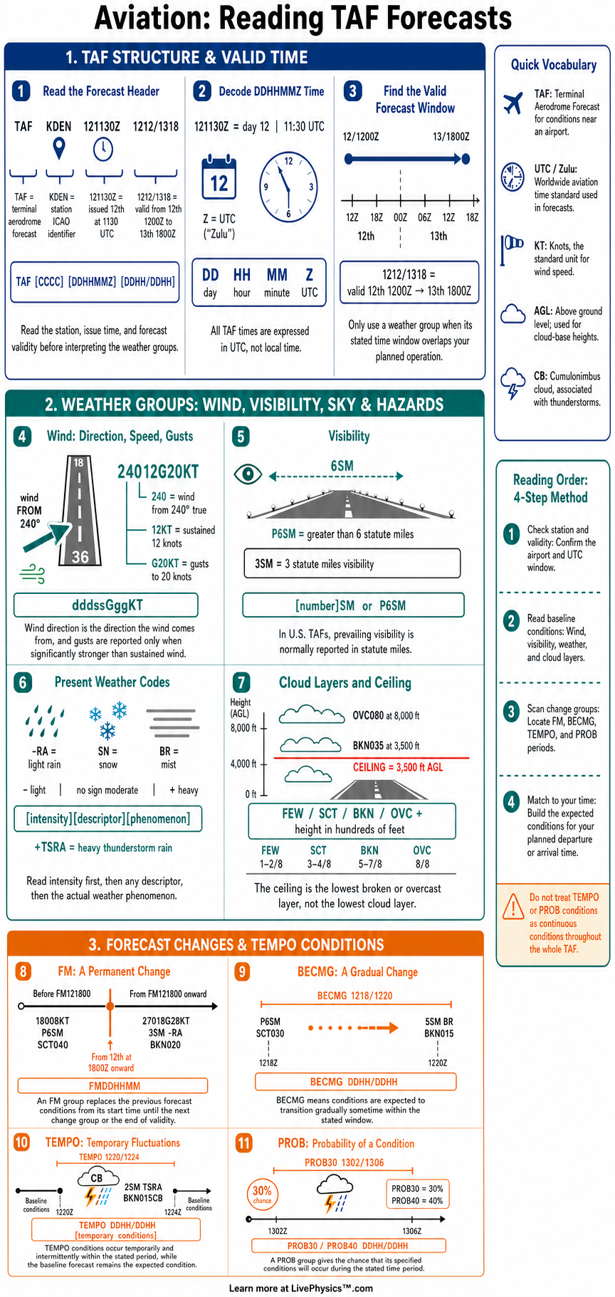
Terminal Aerodrome Forecasts, called TAFs, provide expected weather conditions at and near an airport. Pilots use them to plan departures, arrivals, fuel, alternates, and safe go or no-go decisions. This cheat sheet helps students read the coded forecast in the order it appears.
It also explains the change groups that show when conditions may change.
A TAF begins with its type, airport identifier, issue time, and valid period. The forecast then lists wind, visibility, weather, sky condition, and optional wind shear. Change groups such as FM, TEMPO, PROB, and BECMG describe forecast transitions or temporary conditions.
Careful reading means tracking both the weather and the time period that applies to it.
Key Facts
- A TAF begins with the forecast type, airport identifier, issue time, and valid period in UTC.
- Wind group 18010KT means wind from 180 degrees true at 10 knots.
- Wind group VRB03KT means variable wind direction at 3 knots.
- Wind group 22012G18KT means wind from 220 degrees at 12 knots with gusts to 18 knots.
- Visibility 3SM means three statute miles of prevailing visibility.
- Cloud group BKN020 means broken clouds with a base at 2,000 feet above ground level.
- FM121800 means conditions beginning at 1800 UTC on the 12th replace the previous forecast conditions.
- TEMPO 1218/1222 2SM TSRA means thunderstorms and rain with two statute miles visibility may occur temporarily from 1800 to 2200 UTC on the 12th.
Vocabulary
- TAF
- A Terminal Aerodrome Forecast is a coded prediction of weather conditions expected near an airport.
- UTC
- UTC is the worldwide time standard used in aviation weather products and flight operations.
- Ceiling
- A ceiling is the lowest broken, overcast, or vertical visibility layer reported above the ground.
- FM group
- An FM group marks a rapid and lasting forecast change that replaces previous prevailing conditions.
- TEMPO group
- A TEMPO group describes conditions expected to occur temporarily for less than half of its listed period.
- Amendment
- An amendment is an updated TAF issued when significant forecast changes are needed.
Common Mistakes to Avoid
- Reading TAF times as local time is wrong because TAF issue and valid times use UTC. Convert UTC to local time before making a flight plan.
- Treating a TEMPO group as the expected weather for the entire period is wrong because it describes intermittent conditions. Keep the prevailing forecast active outside the temporary occurrences.
- Continuing to use conditions before an FM group is wrong because the FM group replaces the previous forecast. Read all later conditions as the new prevailing forecast until another change group starts.
- Confusing cloud heights with mean sea level is wrong because TAF cloud heights are hundreds of feet above ground level. BKN020 means a 2,000 foot above ground level base.
- Ignoring the issue time and AMD or COR labels is wrong because a newer amended or corrected forecast may supersede an older one. Use the most current valid TAF.
Practice Questions
- 1 Decode the wind group 31015G25KT and state the direction, sustained speed, and gust speed.
- 2 A TAF contains OVC008 1SM BR. State the cloud ceiling, visibility, and weather condition.
- 3 A forecast has TEMPO 1419/1423 2SM TSRA after prevailing conditions of P6SM SCT040. Describe the expected conditions during that four-hour period.
- 4 Explain why a pilot should compare each TAF change group with the planned arrival time instead of relying only on the first forecast line.
Understanding Reading TAF Forecasts
A TAF is a forecast for conditions within about five statute miles of an airport. In the United States, routine TAFs usually cover 24 or 30 hours. The forecast uses Coordinated Universal Time, also called UTC or Zulu time.
A student should first identify the station and then note the beginning and ending dates and times of validity. This prevents using a forecast section before it begins or after it has expired.
The initial forecast line describes conditions expected at the start of the valid period. Wind is given as direction in true degrees followed by speed in knots. For example, 24012G20KT means wind from 240 degrees at 12 knots with gusts to 20 knots.
Visibility is normally stated in statute miles. Weather codes can show rain, snow, fog, thunderstorms, haze, or other significant conditions. Cloud groups state cloud amount and height above ground level in hundreds of feet.
The FM group means from and introduces a rapid, lasting change. Conditions after an FM group replace the earlier forecast conditions until another change group appears. TEMPO means temporary conditions are expected for less than half of the stated time period.
A TEMPO group does not replace the main forecast. It warns that the listed conditions may occur intermittently. BECMG describes a gradual change over a stated period, though this group is not commonly used in routine United States TAFs.
Probability groups express the chance of specified conditions. PROB30 means a 30 percent chance, while PROB40 means a 40 percent chance. In United States TAFs, probability groups are generally used for convective weather and are paired with a time period.
A PROB group can contain TEMPO, which means temporary conditions have the stated probability of occurring. Pilots should pay close attention to thunderstorms, low visibility, low ceilings, and strong gusts because these conditions can affect airport access and aircraft performance.
Reading a TAF matters because flight planning depends on timing. A forecast of good weather at departure does not guarantee good weather at arrival. Students should make a simple timeline and place every FM, TEMPO, and PROB group on it.
Then compare the expected conditions with personal minimums, aircraft limits, runway direction, and legal requirements. Check the issue time and any AMD or COR label as well, since an amended or corrected TAF can replace an earlier forecast.