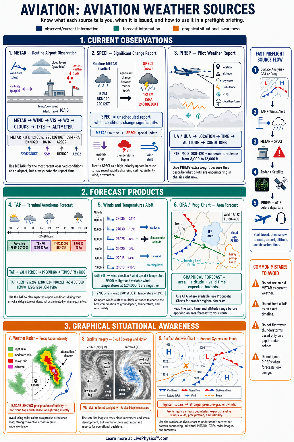
Aviation weather sources give pilots the information needed to plan, delay, divert, or safely complete a flight. This cheat sheet organizes the major observation, forecast, and briefing products used in aviation. Students need it because each source has a different purpose, time period, and level of reliability.
Reading the right source correctly supports sound aeronautical decision making.
Current conditions come from METARs, ATIS broadcasts, automated stations, radar, satellite imagery, and pilot reports. Forecast conditions come from TAFs, graphical forecasts, significant weather charts, winds and temperatures aloft forecasts, and prognostic charts. A complete briefing compares several sources instead of relying on one report.
Pilots must always consider the age, coverage, and limitations of every weather product.
Key Facts
- A METAR is a routine or special observation that reports current airport weather, usually including wind, visibility, present weather, cloud layers, temperature, dew point, and altimeter setting.
- The METAR wind group dddffGggKT means wind from direction ddd at ff knots with gusts to gg knots.
- A TAF is a coded airport forecast, and its valid period tells pilots when the forecast conditions apply.
- In a TAF, FM means conditions change and then prevail from the stated time, while TEMPO means temporary conditions are expected.
- A PIREP is a pilot report, and an urgent PIREP identifies hazards such as severe turbulence, severe icing, or low-level wind shear.
- Radar indicates detected precipitation, so an echo can suggest rain, snow, or hail but does not directly measure cloud ceiling or turbulence.
- Winds aloft forecasts give wind direction in true degrees, wind speed in knots, and temperature in degrees Celsius.
- A complete weather briefing compares observations, forecasts, charts, notices, and pilot reports before a flight decision.
Vocabulary
- METAR
- A METAR is a coded report of observed weather conditions at an airport.
- TAF
- A TAF is a coded forecast of expected weather conditions for a specific airport.
- PIREPs
- PIREPs are reports from pilots describing weather conditions encountered during flight.
- Ceiling
- A ceiling is the height of the lowest broken or overcast cloud layer, or vertical visibility into an obscuration.
- Prognostic chart
- A prognostic chart is a forecast map that shows expected weather systems and hazards for a future time.
- Winds aloft
- Winds aloft are forecast wind direction, wind speed, and temperature at selected altitudes.
Common Mistakes to Avoid
- Treating a METAR as a forecast is wrong because it describes observed conditions at the report time, not what conditions will be later.
- Assuming radar shows all hazards is wrong because radar mainly detects precipitation and may not reveal icing, turbulence, cloud bases, or dry thunderstorms.
- Reading a TAF without checking its valid time is wrong because the forecast may not apply to the planned departure or arrival period.
- Using forecast wind direction as magnetic direction is wrong because winds aloft directions are normally reported in true degrees.
- Relying on one weather source is wrong because each product has limits, and hazards become clearer when observations, forecasts, charts, and PIREPs are compared.
Practice Questions
- 1 Decode the METAR wind group 24018G28KT and state the wind direction, sustained speed, and gust speed.
- 2 A flight is planned for 1800 UTC. A TAF is valid from 1200 UTC to 1200 UTC the next day and includes TEMPO 1822 3SM TSRA. State the time window during which temporary thunderstorms and rain are forecast.
- 3 A winds aloft forecast at 6000 feet gives 27035 and the aircraft true airspeed is 120 knots while flying west. Calculate the approximate groundspeed with the wind directly from the west.
- 4 Explain why a pilot should compare radar imagery with PIREPs and METARs before deciding whether precipitation along a route is safe to cross.
Understanding Aviation Weather Sources
Weather information is most useful when it is sorted into observations and forecasts. Observations describe conditions that have already been measured or seen. A METAR gives a coded report of weather at an airport, often issued hourly and updated when important conditions change.
ATIS provides airport-specific operational information, including runway use, weather, and notices. Automated systems such as AWOS and ASOS give frequent local observations, but they cannot always detect every cloud layer, obstruction, or hazard that a trained observer can report.
A TAF is an airport forecast that describes expected weather during a stated valid period. It includes wind, visibility, weather, clouds, and important changes. Groups such as FM show a lasting change beginning at a specified time.
TEMPO shows temporary conditions, while PROB shows a probability of conditions occurring when that group is authorized. Pilots should compare the forecast with the current METAR to judge whether weather is improving, stable, or changing faster than expected.
Weather charts show the broader picture beyond one airport. Radar displays areas where precipitation is being detected, but it does not directly show cloud bases, icing severity, or turbulence. Satellite imagery shows cloud patterns and movement over wide areas.
Infrared satellite imagery is especially useful at night because it senses temperature differences. Surface analysis charts, prog charts, and significant weather charts help pilots identify fronts, low pressure systems, thunderstorms, turbulence, icing, and areas of reduced visibility.
Winds and temperatures aloft forecasts support altitude selection, fuel planning, groundspeed estimates, and icing awareness. Winds are normally given as the direction the wind comes from and its speed in knots. Temperature is reported in degrees Celsius.
A strong headwind increases flight time and fuel use, while a tailwind reduces them. Pilots must remember that forecast wind directions are true directions, whereas headings and many cockpit references use magnetic direction.
Pilot reports add direct human observations from aircraft in flight. A PIREP can report cloud tops, turbulence, icing, wind shear, and visibility that automated equipment may miss. Urgent reports highlight severe or hazardous conditions and deserve immediate attention.
During study, focus on decoding time, location, altitude, trend words, and validity periods. In real flight planning, build a weather picture from multiple sources, then continue checking updates before departure and while en route.