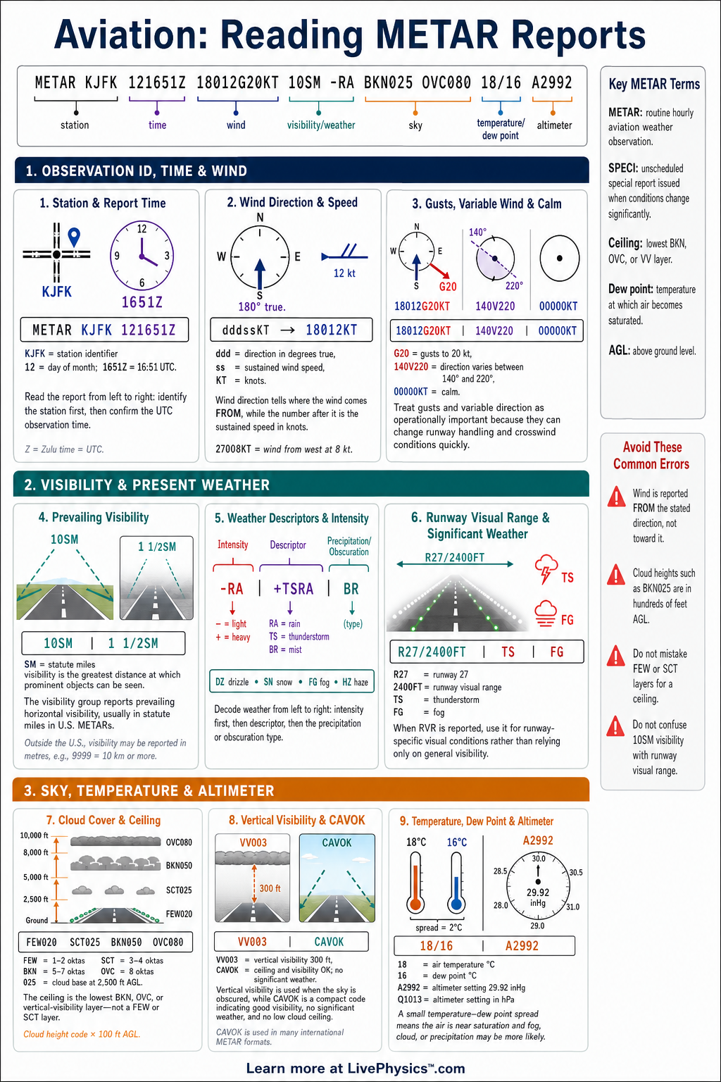
METAR reports are standardized aviation weather observations used by pilots, dispatchers, and air traffic services. They give a quick picture of conditions at an airport at a specific time. This cheat sheet helps students break a long coded report into clear, useful pieces.
It supports safer flight planning and better operational decisions.
A METAR normally begins with the report type, station identifier, observation time, wind, visibility, and present weather. It then gives cloud layers, temperature and dew point, and an altimeter setting or sea-level pressure. Optional groups can report runway visual range, recent weather, wind shear, and forecast trends.
Reading the groups in order makes the report much easier to interpret.
Key Facts
- A routine METAR begins with METAR, while SPECI identifies a special report issued because conditions changed.
- The time group DDHHMMZ gives the day of the month, hour, and minute in Coordinated Universal Time.
- The wind group dddssKT gives wind direction in degrees true and wind speed in knots, as in 18015KT.
- A gust is written with G, so 18015G25KT means wind from 180 degrees at 15 knots with gusts to 25 knots.
- Cloud coverage codes are FEW for 1 to 2 oktas, SCT for 3 to 4 oktas, BKN for 5 to 7 oktas, and OVC for 8 oktas.
- A cloud group such as BKN030 means broken cloud with a base at 3,000 feet above aerodrome level.
- The temperature and dew point group 18/12 means air temperature 18 degrees Celsius and dew point 12 degrees Celsius.
- Q1013 gives altimeter pressure in hectopascals, while A2992 gives altimeter pressure as 29.92 inches of mercury.
Vocabulary
- METAR
- A METAR is a coded routine weather observation describing conditions at an aerodrome.
- Aerodrome
- An aerodrome is an area used for aircraft arrivals, departures, and ground operations.
- Dew point
- The dew point is the temperature at which air becomes saturated and water vapour can condense.
- Visibility
- Visibility is the greatest distance at which important objects can be seen and identified.
- Altimeter setting
- The altimeter setting is the pressure value pilots set so the altimeter indicates the correct altitude.
- Ceiling
- A ceiling is the height of the lowest broken or overcast cloud layer, or vertical visibility into an obscuration.
Common Mistakes to Avoid
- Reading the wind direction as the direction the wind travels toward is wrong because METAR wind direction states where the wind comes from.
- Treating cloud height digits as feet is wrong because the three digits represent hundreds of feet, so SCT025 means 2,500 feet.
- Assuming all visibility values use the same unit is wrong because many international reports use metres while United States reports often use statute miles.
- Ignoring the M before a temperature or dew point is wrong because M changes the value to a negative Celsius temperature.
- Using Q1013 as a height setting is wrong because it is an atmospheric pressure value for the aircraft altimeter.
Practice Questions
- 1 Decode the wind group 22018G28KT, including direction, steady speed, and gust speed.
- 2 A METAR contains BKN015 OVC040. State the height and coverage of each cloud layer, and identify the ceiling.
- 3 Interpret the group M03/M06 Q1007 by stating the temperature, dew point, and altimeter setting.
- 4 A report shows 08008KT 2000 BR BKN004. Explain why these conditions could create operational concerns even though the wind speed is low.
Understanding Reading METAR Reports
A METAR is a routine aviation weather report issued for a specific aerodrome. Most reports are made at fixed times, often every half hour or hour, although special reports may be issued when conditions change quickly. The word METAR identifies a routine observation, while SPECI identifies a special observation.
The four-letter station code tells the reader where the observation was taken. The date and time group uses Coordinated Universal Time, also called UTC, so pilots in different locations use the same clock.
Wind is reported as the direction the wind comes from, followed by its speed in knots. For example, 27012KT means wind from 270 degrees at 12 knots. Gusts appear after a G, so 27012G20KT means gusts up to 20 knots.
VRB shows a variable wind direction, and 00000KT indicates calm wind. A wind direction of 360 means wind from true north, not a direction of zero. Pilots compare wind direction with runway heading to estimate headwind, tailwind, and crosswind components.
Visibility is usually given in metres in international METAR format and in statute miles in United States reports. Present weather codes describe conditions that affect flight, such as rain, snow, fog, thunderstorms, or haze. A minus sign means light intensity, no sign means moderate intensity, and a plus sign means heavy intensity.
Cloud groups use FEW, SCT, BKN, and OVC to show increasing sky coverage. The three digits after a cloud amount give the cloud-base height in hundreds of feet above the aerodrome. BKN020 therefore reports broken cloud at 2,000 feet.
Temperature and dew point are reported in degrees Celsius, separated by a slash. An M before a number means minus, so M05 means minus 5 degrees Celsius. A small spread between temperature and dew point can warn of high humidity, mist, fog, or low cloud.
The pressure group is commonly given as Q followed by hectopascals outside the United States, while A followed by four digits gives inches of mercury in United States reports. Pilots set this value on the altimeter to obtain accurate altitude information. The final trend section, when present, indicates expected short-term changes such as TEMPO for temporary conditions or BECMG for gradual change.