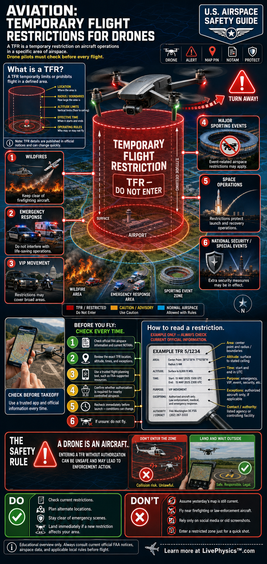
Temporary Flight Restrictions, or TFRs, are short-term limits on aircraft operations in a defined area. They can protect emergency crews, major public events, military activity, space launches, and national security operations. Drone pilots must treat a TFR as a serious flight boundary because a small drone can create major risks near aircraft or people on the ground.
A TFR is published through an FAA Notice to Air Missions, often called a NOTAM. Each notice identifies the restricted location, altitude range, start time, end time, and any allowed operations. A drone pilot must check current restrictions before every flight because a clear location in the morning may become restricted later that day.
Understanding Aviation, Temporary Flight Restrictions for Drones
A Temporary Flight Restriction is a legal limit placed on a section of airspace for a limited time. In the United States, the Federal Aviation Administration issues these restrictions through Notices to Air Missions. A notice gives the boundaries in coordinates or distance from a reference point.
It states the vertical limits, often using altitude above ground level or mean sea level. It includes exact beginning and ending times in coordinated universal time. Reading all of these details matters because a restriction may apply only at certain heights or during certain hours.
TFRs exist for several reasons. Wildfires are a common example. Firefighting aircraft may fly low, turn sharply, and carry water or fire retardant.
A drone near that operation can force aircraft to stop flying, even if the drone is far from the fire itself. Other TFRs may protect disaster response areas, large stadium events, presidential travel, rocket launches, or sensitive security locations. The reason for the restriction helps a pilot understand the hazard, but the rule applies whether or not the pilot can see the activity.
Drone pilots need to separate permanent airspace rules from temporary restrictions. Controlled airspace near many airports may require FAA authorization before a drone flight. A TFR is different because it can be created quickly and can override a location that normally permits flight.
An authorization from a system such as LAANC does not automatically permit flight through a newly issued TFR. The pilot must review the current notice and follow its specific conditions. Some TFRs allow certain aircraft with approval, while others prohibit nearly all drone operations.
Good preflight planning starts before the drone is powered on. Check the FAA NOTAM information, approved flight planning tools, local airport conditions, and the planned flight time. Confirm the map scale because a boundary can extend farther than it appears on a phone screen.
Check the altitude limit in the notice, since the restriction may cover airspace from the surface upward. If a TFR begins during the planned flight, land and clear the area before the listed start time. Save enough battery for a safe return instead of planning to fly until the final minute.
Students should focus on interpreting location, altitude, time, and authority. Coordinates identify the horizontal area. Altitude limits identify the vertical layer.
Times show when the rule applies, and the issuing authority explains the purpose. A drone flight can be legal under one rule yet prohibited under another, so pilots must check the complete set of requirements. The safest decision during uncertainty is to delay the flight and verify the restriction with an official FAA source.
Key Facts
- A TFR is a temporary FAA restriction that may prohibit or limit drone operations in a defined area.
- Distance = speed × time
- Altitude change = climb rate × time
- 1 statute mile = 5,280 ft
- 1 nautical mile = 6,076 ft
- AGL = altitude measured above the local ground surface
Vocabulary
- Temporary Flight Restriction
- A Temporary Flight Restriction is a short-term legal limit on aircraft operations within a specified area of airspace.
- NOTAM
- A Notice to Air Missions is an official FAA notice that provides pilots with time-sensitive flight information.
- AGL
- Above ground level is an altitude measured from the surface directly below an aircraft.
- Controlled airspace
- Controlled airspace is airspace where air traffic services manage aircraft activity and drone operations may require authorization.
- LAANC
- Low Altitude Authorization and Notification Capability is an FAA system that provides automated drone airspace authorizations in some areas.
Common Mistakes to Avoid
- Assuming a previous airspace check is still valid. TFRs can begin or change on short notice, so check official current information before every flight.
- Treating a LAANC authorization as permission to ignore a TFR. A temporary restriction can impose stricter limits than the normal controlled-airspace authorization.
- Reading only the map boundary and ignoring altitude or time. A notice applies according to all listed dimensions, including its vertical limits and exact start time.
- Flying near an emergency scene because the drone is below the altitude of crewed aircraft. Emergency aircraft can operate very low, and any drone can disrupt their mission.
Practice Questions
- 1 A TFR begins at 1800 UTC. A pilot plans to fly for 22 minutes and needs 8 minutes to land and leave the area. What is the latest time the pilot can launch if the entire flight must end before the TFR begins?
- 2 A drone travels at 24 feet per second for 35 seconds before reaching a TFR boundary. How far does it travel in feet?
- 3 A drone pilot has valid controlled-airspace authorization near an airport, then finds that a wildfire TFR now covers the launch site. Explain why the pilot should not fly and identify the information that must be checked before rescheduling.