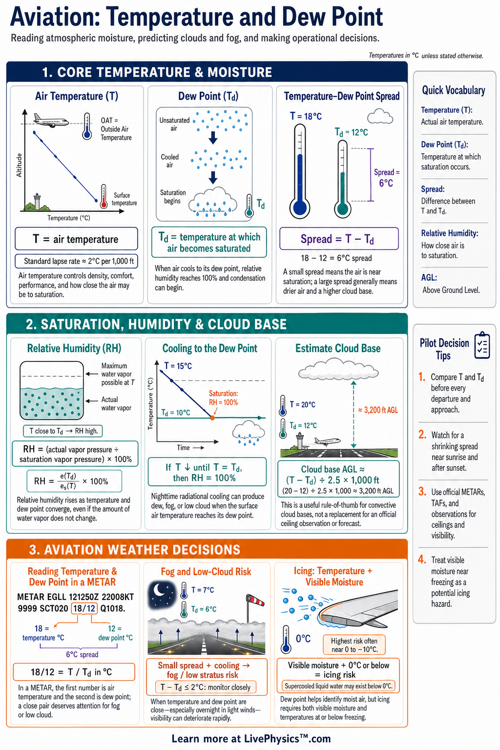
Temperature and dew point are essential weather values for pilots because they help predict clouds, fog, frost, visibility, and icing risk. Aviation weather reports provide both values, often in a compact coded form. This cheat sheet helps students read those values quickly and connect them to flight conditions.
It also supports better preflight planning and weather decisions.
Air temperature measures how warm or cold the air is, while dew point shows the temperature at which the air becomes saturated. The difference between them is called the temperature dew point spread. A small spread means the air is close to saturation and clouds or fog may form.
A larger spread usually means drier air and a lower immediate risk of condensation.
Key Facts
- Dew point is the temperature at which air becomes saturated with its current amount of water vapor.
- Temperature minus dew point equals the temperature dew point spread.
- A temperature dew point spread near zero degrees indicates air that is near saturation.
- Relative humidity increases as air temperature falls toward a steady dew point.
- A rough cloud-base estimate is spread in degrees Celsius times 400 feet above ground level.
- In a METAR, temperature and dew point are reported in degrees Celsius as temperature slash dew point.
- The letter M in a METAR temperature group means the value is below zero degrees Celsius.
- Visible moisture with an air temperature near or below zero degrees Celsius can create an airframe icing risk.
Vocabulary
- Air temperature
- Air temperature is the measured warmth or coldness of the surrounding air, usually reported in degrees Celsius.
- Dew point
- Dew point is the temperature at which the current water vapor in air causes the air to become saturated.
- Relative humidity
- Relative humidity is the percentage of water vapor in the air compared with the maximum amount the air can hold at that temperature.
- Temperature dew point spread
- The temperature dew point spread is the difference found by subtracting dew point from air temperature.
- Lifting condensation level
- The lifting condensation level is the approximate height where rising air cools to its dew point and cloud condensation can begin.
- METAR
- A METAR is a routine aviation weather report that gives current observed conditions at an airport.
Common Mistakes to Avoid
- Confusing dew point with the actual air temperature is wrong because dew point describes moisture content and saturation, not current warmth.
- Assuming a large temperature dew point spread guarantees clear skies is wrong because fronts, lifting, terrain, and other processes can still form clouds.
- Subtracting temperature from dew point is wrong because the standard spread is air temperature minus dew point.
- Ignoring the letter M in a METAR is wrong because M indicates a negative Celsius value and changes the weather interpretation.
- Using the cloud-base estimate as an exact altitude is wrong because it is only a rough planning tool and local conditions can change the result.
Practice Questions
- 1 A METAR reports a temperature of 22 degrees Celsius and a dew point of 16 degrees Celsius. Calculate the temperature dew point spread.
- 2 The temperature is 12 degrees Celsius and the dew point is 7 degrees Celsius. Estimate the cloud base in feet above ground level using spread times 400 feet.
- 3 Decode the temperature and dew point group M02 slash M04 from a METAR.
- 4 Explain why a clear, calm night with a falling air temperature and a steady dew point can create a higher risk of morning fog or frost.
Understanding Temperature and Dew Point
Air can hold water vapor, but the amount it can hold changes with temperature. Warm air can contain more water vapor than cold air. Dew point is the temperature at which the existing water vapor would saturate the air.
If air cools to its dew point, condensation begins on suitable particles or surfaces. This can form cloud droplets, fog, dew, frost, or ice depending on the temperature and conditions.
Pilots often compare the reported temperature and dew point to find the spread. Temperature minus dew point equals the temperature dew point spread. A spread of only a few degrees means saturation may be near.
When the spread falls toward zero, fog, low cloud, or precipitation becomes more likely. A rising temperature with a steady dew point usually increases the spread and lowers relative humidity. Cooling air during the evening often reduces the spread, which is why radiation fog is common overnight and near sunrise.
A useful planning estimate links the spread to cloud base. When air rises, it cools until it reaches its lifting condensation level. In aviation training, the cloud base can be estimated in feet above ground level by multiplying the temperature dew point spread in degrees Celsius by about 400.
This is an estimate, not a guarantee. Terrain, fronts, wind, vertical motion, and changing moisture can produce clouds at different heights or prevent cloud formation altogether.
Temperature and dew point appear in METAR reports as two numbers separated by a slash. A report of 18 slash 14 means an air temperature of 18 degrees Celsius and a dew point of 14 degrees Celsius. A letter M before a value means minus.
For example, M03 slash M05 means the air temperature is minus 3 degrees Celsius and the dew point is minus 5 degrees Celsius. Reading negative values accurately matters because visible moisture at freezing temperatures can create airframe icing hazards.
Study the trend as well as the current values. Notice whether temperature is falling toward dew point, whether wind is becoming light, and whether skies are clearing at night. These conditions can support fog or frost formation.
Also consider the surface temperature, which can be lower than the reported air temperature. Frost on wings, tail surfaces, or propellers changes airflow and must be removed before flight. Temperature and dew point do not make decisions by themselves, but they provide a fast and powerful warning of changing weather.