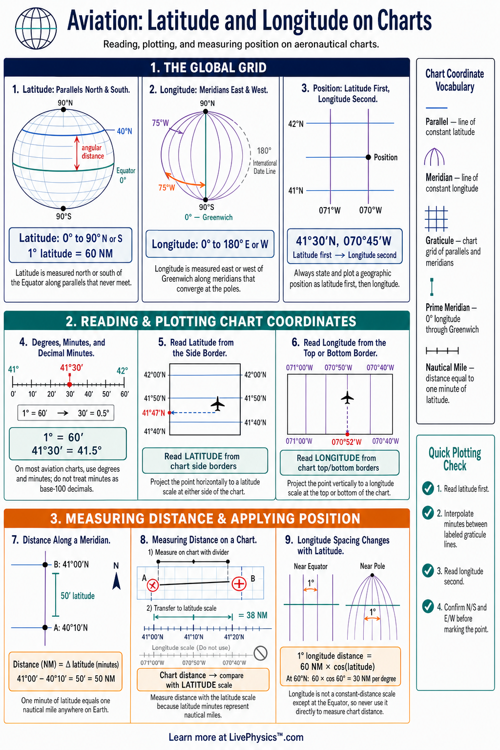
Latitude and longitude give pilots a universal way to identify any position on an aviation chart. This cheat sheet explains how to read, plot, and report coordinates accurately. Students need these skills for visual navigation, flight planning, emergency reporting, and using charted waypoints.
Accurate coordinates help crews communicate the same location without relying on landmarks.
Latitude measures distance north or south of the Equator, while longitude measures distance east or west of the Prime Meridian. Both are measured in degrees, minutes, and sometimes seconds or decimal minutes. On most aeronautical charts, latitude lines run horizontally and longitude lines run vertically.
Correctly reading the chart border and using the proper coordinate format are essential navigation habits.
Key Facts
- Latitude is measured from 0 degrees at the Equator to 90 degrees north or 90 degrees south.
- Longitude is measured from 0 degrees at the Prime Meridian to 180 degrees east or 180 degrees west.
- One degree equals 60 minutes, and one minute equals 60 seconds.
- One minute of latitude is approximately equal to one nautical mile.
- The distance represented by one minute of longitude equals one nautical mile times the cosine of the latitude.
- Report a geographic position in the order latitude first, then longitude.
- A coordinate must include its hemisphere letter, such as north, south, east, or west, to identify the correct location.
Vocabulary
- Latitude
- Latitude is the angular distance of a position north or south of the Equator.
- Longitude
- Longitude is the angular distance of a position east or west of the Prime Meridian.
- Parallel
- A parallel is a line of constant latitude that runs around Earth parallel to the Equator.
- Meridian
- A meridian is a line of constant longitude that runs from one pole to the other.
- Nautical mile
- A nautical mile is a navigation distance unit equal to approximately one minute of latitude.
- Chart projection
- A chart projection is a method for representing Earth’s curved surface on a flat chart.
Common Mistakes to Avoid
- Reading longitude before latitude is wrong because aviation position reports normally state latitude first and longitude second.
- Omitting north, south, east, or west is wrong because the same numbers can identify positions in different hemispheres.
- Treating one minute of longitude as one nautical mile everywhere is wrong because meridians converge as latitude increases.
- Confusing decimal minutes with seconds is wrong because 28.5 minutes is not the same as 28 minutes 50 seconds.
- Estimating from the chart grid without checking the border labels is wrong because the labels provide the actual coordinate values and interval size.
Practice Questions
- 1 Convert 42 degrees 30 minutes north into decimal degrees.
- 2 A position is 60 degrees north. Approximately how many nautical miles does one degree of longitude represent at this latitude.
- 3 Write the correct aviation reporting order for a position at 34 degrees 15 minutes south and 118 degrees 20 minutes west.
- 4 Explain why two aircraft separated by the same difference in longitude can be farther apart near the Equator than near the poles.
Understanding Latitude and Longitude on Charts
Latitude and longitude form a geographic grid around Earth. Latitude starts at the Equator, which is zero degrees latitude. It increases to 90 degrees north at the North Pole and 90 degrees south at the South Pole.
Lines of latitude are called parallels because they remain parallel to the Equator. On a chart, they usually appear as horizontal curved or straight lines, depending on the projection used.
Longitude starts at the Prime Meridian, which passes through Greenwich, England. It is zero degrees longitude and extends east or west to 180 degrees. Lines of longitude are called meridians.
They meet at both poles, so they are not parallel. On many aviation charts, meridians are shown as nearly vertical lines. Their spacing can appear different across the chart because Earth is curved and the chart is a flat representation.
A degree is divided into 60 minutes, written with an apostrophe symbol. One minute of latitude is approximately one nautical mile anywhere on Earth. This relationship makes latitude especially useful in aviation navigation.
A minute of longitude equals one nautical mile only at the Equator. It becomes shorter as latitude increases because meridians converge toward the poles. Pilots must not assume that equal longitude differences represent equal ground distances at all locations.
To plot a position, first find the correct latitude on the left or right chart border. Then estimate the minutes between the marked parallels. Next find the longitude on the top or bottom border and estimate its minutes between meridians.
Draw or imagine the horizontal latitude line and vertical longitude line until they meet. State latitude before longitude when reporting a position, and include north or south and east or west every time.
Coordinates may be written in degrees and minutes, such as 51 degrees 28.5 minutes north, 000 degrees 27.0 minutes west. They may also use decimal degrees or degrees, minutes, and seconds. A flight crew must use the format required by the chart, flight plan, GPS, or air traffic service.
Mixing formats causes serious errors. Careful reading matters during diversion planning, search and rescue, oceanic operations, and any flight where a reported position must be exact.