Sign in to save

Bookmark this page so you can find it later.

Sign in to save

Bookmark this page so you can find it later.

Earth Science middle-school May 21, 2026

Why Do Tornadoes Spin?

How storms turn moving air into a tight whirl
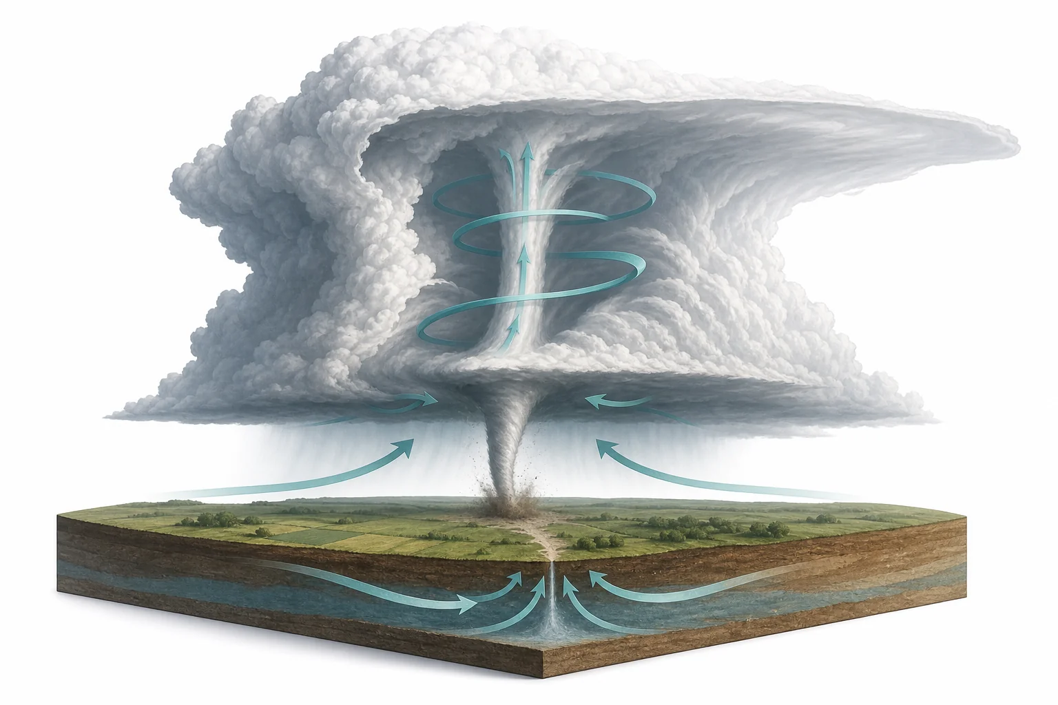
A supercell thunderstorm with rising air below the cloud and a narrow rotating tornado reaching toward the ground

Tornadoes spin because winds at different heights often move at different speeds or in different directions. A strong storm can lift that rolling air and turn part of it upright. As the rising air stretches the spin, the whirl can tighten and rotate faster.

Big Idea. NGSS MS-ESS2-5 connects tornado formation to how uneven heating, water, and moving air drive weather patterns.

A tornado is a fast-spinning column of air that reaches from a thunderstorm toward the ground. It can look sudden, but the spin usually starts long before the funnel appears. The setup begins when air near the ground and air higher up move differently. One layer may blow from the south while another blows from the west. One layer may also move faster. That difference can make air roll like an invisible tube. Inside a strong thunderstorm, warm, moist air rises quickly. The rising air can tilt part of that roll upright and stretch it. When the spin becomes narrow, it turns faster, much like a skater pulling in their arms. Most thunderstorms do not make tornadoes. The strongest tornadoes usually come from supercell thunderstorms, where a broad area of rotating air can last for a long time.

Wind shear starts the roll

Different wind speeds and directions at low and high levels create a horizontal roll of air
Wind shear can roll air sideways before a tornado forms.
The first step is not a funnel cloud. It is wind shear. Wind shear means wind changes with height. Near the ground, wind may be slowed by trees, hills, and friction. Higher in the sky, wind can move faster and from a different direction. This difference can make a layer of air roll sideways, like a pencil rolling across a desk. The air is not yet a tornado. It is a horizontal spin spread over a wide area. Weather scientists look for this kind of setup because it can give a storm a source of rotation. Wind shear can happen on many storm days, but it does not always lead to severe weather. A storm also needs strong rising air and the right temperature and moisture pattern.

Tornado spin often begins as sideways rolling air.

An updraft tilts the spin
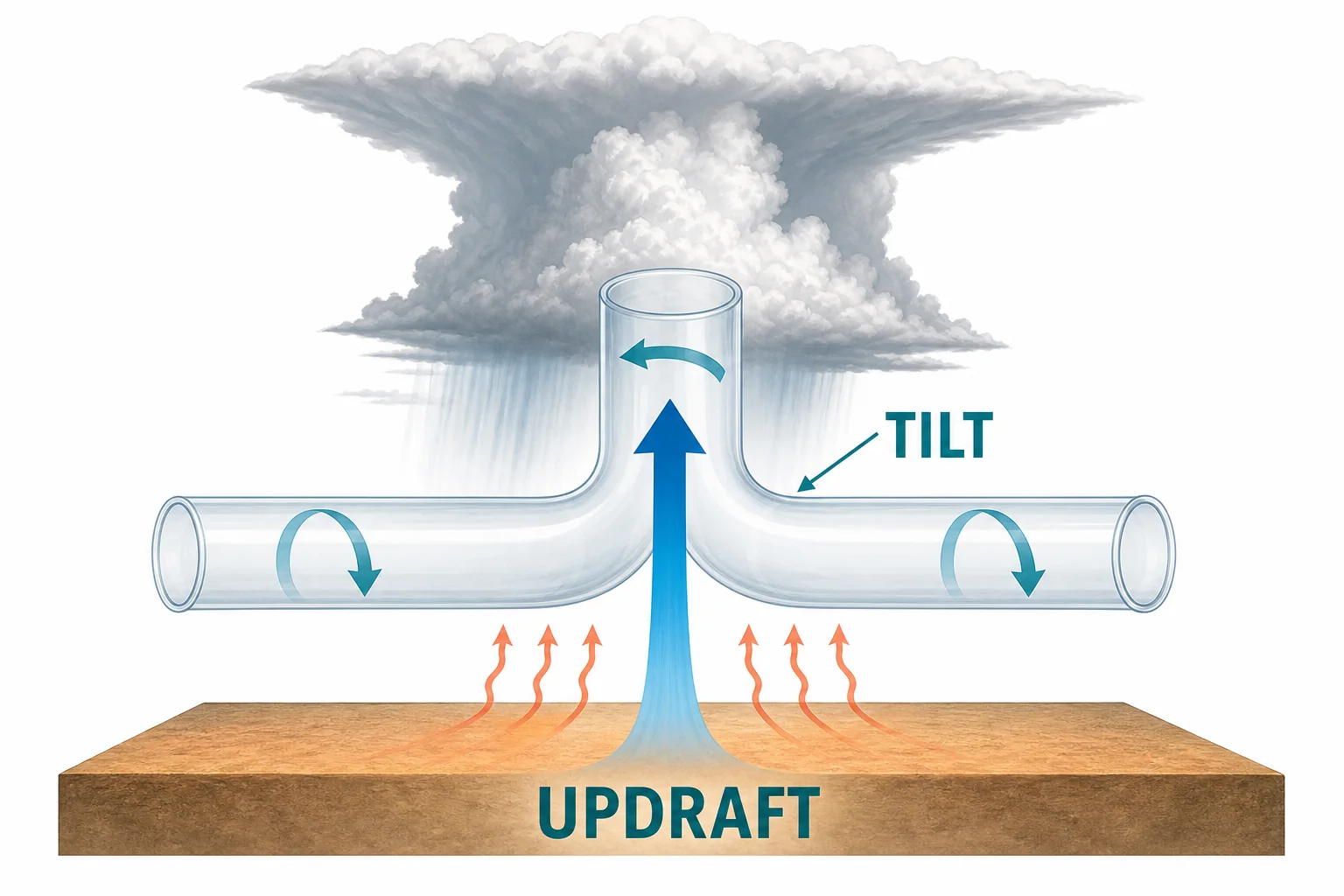
A thunderstorm updraft lifts a sideways rolling tube of air and tilts part of the spin upward
Rising air can tilt sideways spin into the storm.
A thunderstorm grows when warm, moist air rises. This rising air is called an updraft. In a strong storm, the updraft can pull air upward faster than nearby air sinks or spreads out. If a horizontal roll of air is nearby, the updraft can lift one part of it. The roll begins to tilt from sideways toward vertical. This does not make a tornado by itself. It makes a rotating region inside the storm possible. The tilt matters because a tornado must spin around a mostly vertical axis. The storm is changing the direction of the spin. A helpful way to picture it is a rolling tube being grabbed in the middle and pulled upward. The tube bends, and part of the rotation points up and down.

A storm updraft can turn horizontal spin into vertical spin.

Supercells organize rotation
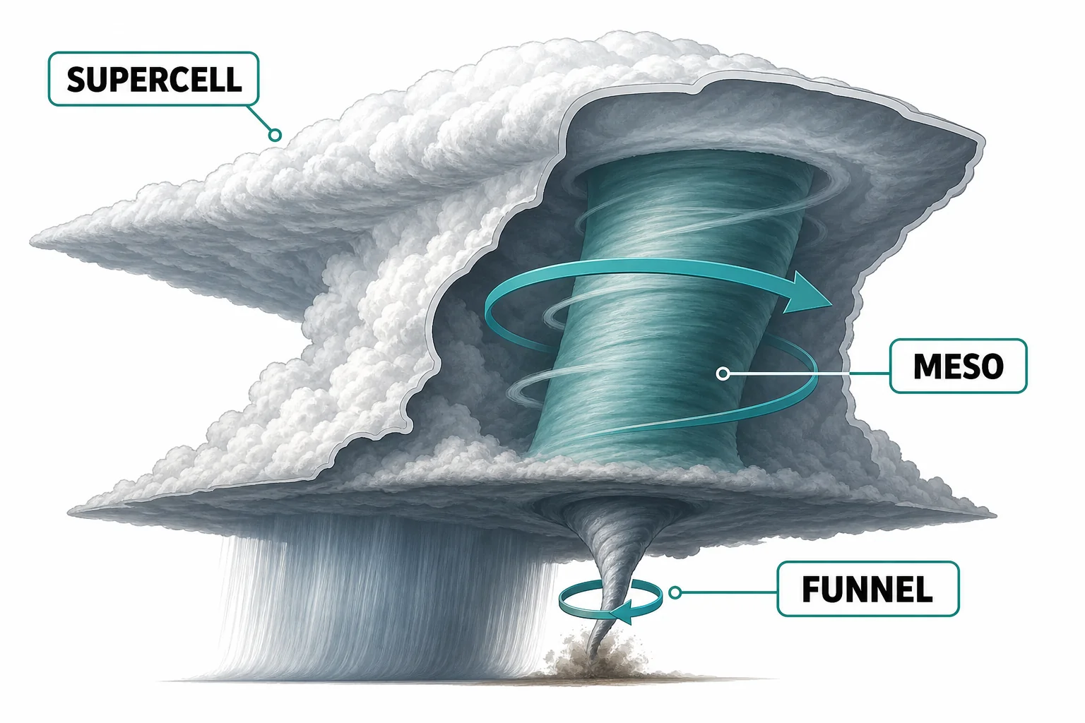
A supercell thunderstorm with a broad rotating updraft above a smaller possible tornado region
A mesocyclone is a broad rotating part of a supercell.
A supercell is a long-lasting thunderstorm with a rotating updraft. That rotating updraft is called a mesocyclone. It is much wider than a tornado, often several kilometers across. The mesocyclone forms when strong wind shear and a powerful updraft work together. Because the updraft keeps rotating, the storm can stay organized for a long time. This gives smaller areas of spin more chances to grow under the cloud base. Many supercells never produce a tornado. The storm still needs the right balance of rising air, sinking air, moisture, and temperature near the ground. Scientists study supercells because they show how rotation can be stored and focused inside a storm. A tornado is the small, intense part of a much larger weather system.

A tornado is much smaller than the rotating storm that can create it.

Stretching speeds up spin
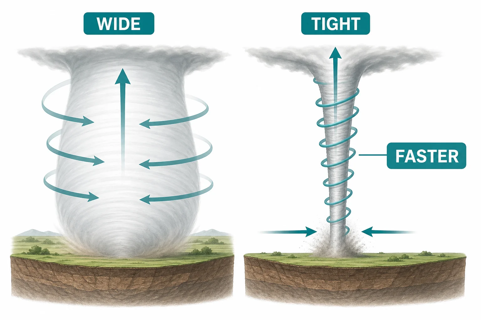
A wide rotating column narrows and spins faster as air rises and stretches it upward
Stretching a rotating column can increase its spin.
Once air is spinning, stretching can make it spin faster. This happens because the rotating air becomes narrower. The same idea appears in ice skating. A skater spins faster when they pull their arms close to their body. In a storm, rising air can stretch a rotating column upward. At the same time, air near the ground can be pulled inward toward lower pressure under the storm. As the column narrows, the rotation rate increases. This is why a broad, slow rotation can become a tight, fast one. The process is not magic. It is a change in shape and motion. The tornado becomes dangerous when the rotating column reaches the ground and wind speeds become strong enough to damage buildings, trees, and vehicles.

Narrower rotating air can spin faster.

Reaching the ground
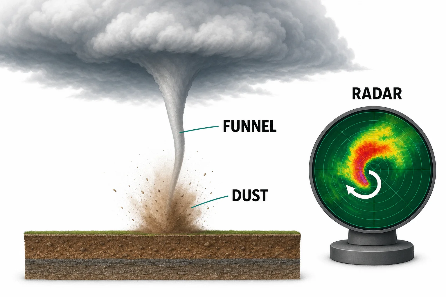
A tornado circulation connects a storm cloud to the ground, with dust at the surface showing contact
A tornado is rotating air that reaches the ground.
A visible funnel is made of tiny water droplets and dust, not solid cloud material. The rotating air can exist before the funnel is easy to see. A tornado is counted when the rotating column of air is in contact with the ground. Sometimes the funnel from the cloud does not look like it reaches all the way down, but dust or debris at the surface shows that the circulation has reached the ground. This is why trained spotters and radar are both important. Radar can show rotation inside a storm, while spotters can report what is happening at the surface. Tornado warnings are issued when a tornado is seen or when radar shows strong signs that one may be forming. The safest response is to move to a sturdy shelter right away.

Ground contact, not just a visible funnel, makes it a tornado.

Vocabulary

Wind shear
A change in wind speed or direction over distance, often with height above the ground.
Updraft
A rising current of air inside a cloud or thunderstorm.
Supercell
A strong thunderstorm with a long-lasting rotating updraft.
Mesocyclone
A broad rotating region inside a supercell thunderstorm.
Funnel cloud
A visible rotating cone of condensed water droplets that extends from a cloud but may not reach the ground.
Tornado
A rotating column of air connected to a thunderstorm and in contact with the ground.

In the Classroom

Model wind shear with stacked cards

20 minutes | Grades 6-8

Students slide two clear plastic sheets or index cards in different directions over a layer of small paper dots. They observe how different motions in layers can create rolling motion in between.

Spin and stretch demonstration

15 minutes | Grades 6-8

Students compare the spin of a rotating chair or turntable with arms or weights held out and then brought inward. Connect the faster spin to a narrowing column of rotating air in a storm.

Storm ingredients concept map

25 minutes | Grades 6-8

Students build a concept map linking moisture, warm air, wind shear, updrafts, supercells, and tornadoes. They mark which ingredients are common and which ones must combine in a specific way.

Key Takeaways

  • Tornado spin often begins when winds change speed or direction with height.
  • A thunderstorm updraft can tilt sideways rolling air into a vertical rotation.
  • Supercell thunderstorms can organize broad rotation called a mesocyclone.
  • Stretching a rotating column can make it narrower and faster.
  • A tornado is present when rotating air from a storm reaches the ground.