Sign in to save

Bookmark this page so you can find it later.

Sign in to save

Bookmark this page so you can find it later.

Environmental Science middle-school May 24, 2026

Why Are There So Many Different Biomes?

Climate patterns shape where life can thrive
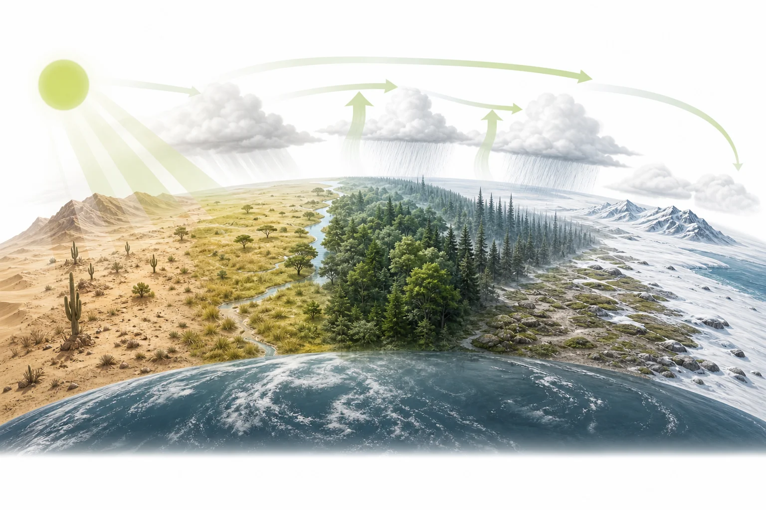
World map showing major biome regions such as rainforest, desert, grassland, tundra, and forest in relation to latitude

There are many biomes because Earth does not get the same heat and rain everywhere. Sunlight, winds, mountains, oceans, and seasons create different climates. Plants and animals live where the climate gives them the water, temperature, and food they need.

Big Idea. NGSS MS-LS2-2 connects biome patterns to how ecosystems depend on physical and biological parts of the environment.

A rainforest and a desert can both be warm, but they cannot exist in the same climate. A rainforest needs steady rain through much of the year. A desert forms where air is dry and rainfall is rare. The difference starts with sunlight. Near the equator, sunlight hits Earth more directly. Near the poles, the same energy spreads over a larger area. That uneven heating helps drive winds, storms, ocean currents, and rainfall patterns. Mountains and distance from the ocean add more local effects. Over time, plants and animals sort into places where they can survive. Those large living regions are called biomes. Use the Biomes of the World cheat sheet to compare them as you read. Biomes are not random patches on a map. They are clues to how energy and water move around Earth.

Sunlight sets the pattern
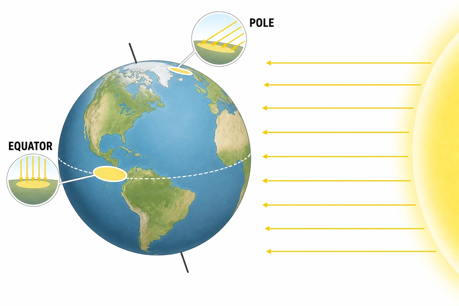
Diagram of sunlight striking Earth at different angles near the equator and near the poles
Solar angle changes how much energy reaches the surface
Latitude is one of the biggest reasons biomes form in bands across the planet. Near the equator, the Sun is high in the sky for much of the year. Its light strikes the ground more directly. That adds more energy to land, water, and air. Near the poles, sunlight arrives at a lower angle. The same amount of light spreads over a wider surface. It also passes through more atmosphere. Less energy reaches each square meter. This is why tropical regions are usually warm, while polar regions are cold. Temperature controls how fast water evaporates, how long snow stays frozen, and which plants can grow. A cactus, a spruce tree, and a moss all have different limits. Solar angle does not explain every biome by itself, but it starts the global climate pattern that other forces build on.

Latitude helps set the temperature limits for each biome.

Warm air moves water
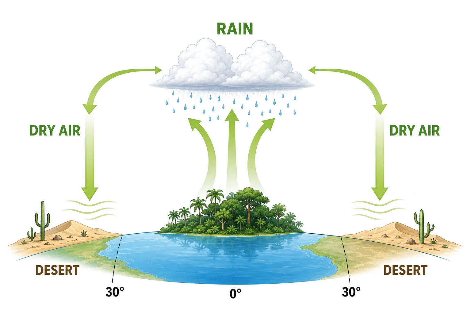
Cross section of Earth atmosphere showing rising moist air near the equator, rain clouds, and sinking dry air near subtropical deserts
Rising air brings rain, sinking air often brings dry weather
Heat also moves water through the air. Warm air near the equator rises because it is less dense than cooler air around it. As it rises, it cools. Water vapor condenses into clouds and rain. This helps explain why many tropical rainforests grow near the equator. Farther north and south, dry air sinks back toward the surface. Sinking air warms up and can hold more water vapor, so clouds are less likely to form. Many major deserts lie in these dry zones near 30 degrees latitude. This is not because deserts are always the hottest places. It is because they often sit under dry, sinking air. Prevailing winds then carry air masses across continents. Some places get moist air from oceans. Others get dry air from land. Rainfall patterns decide whether a region can support forests, grasslands, shrublands, or deserts.

Rainfall is often the difference between a forest and a desert.

Oceans and mountains redirect climate
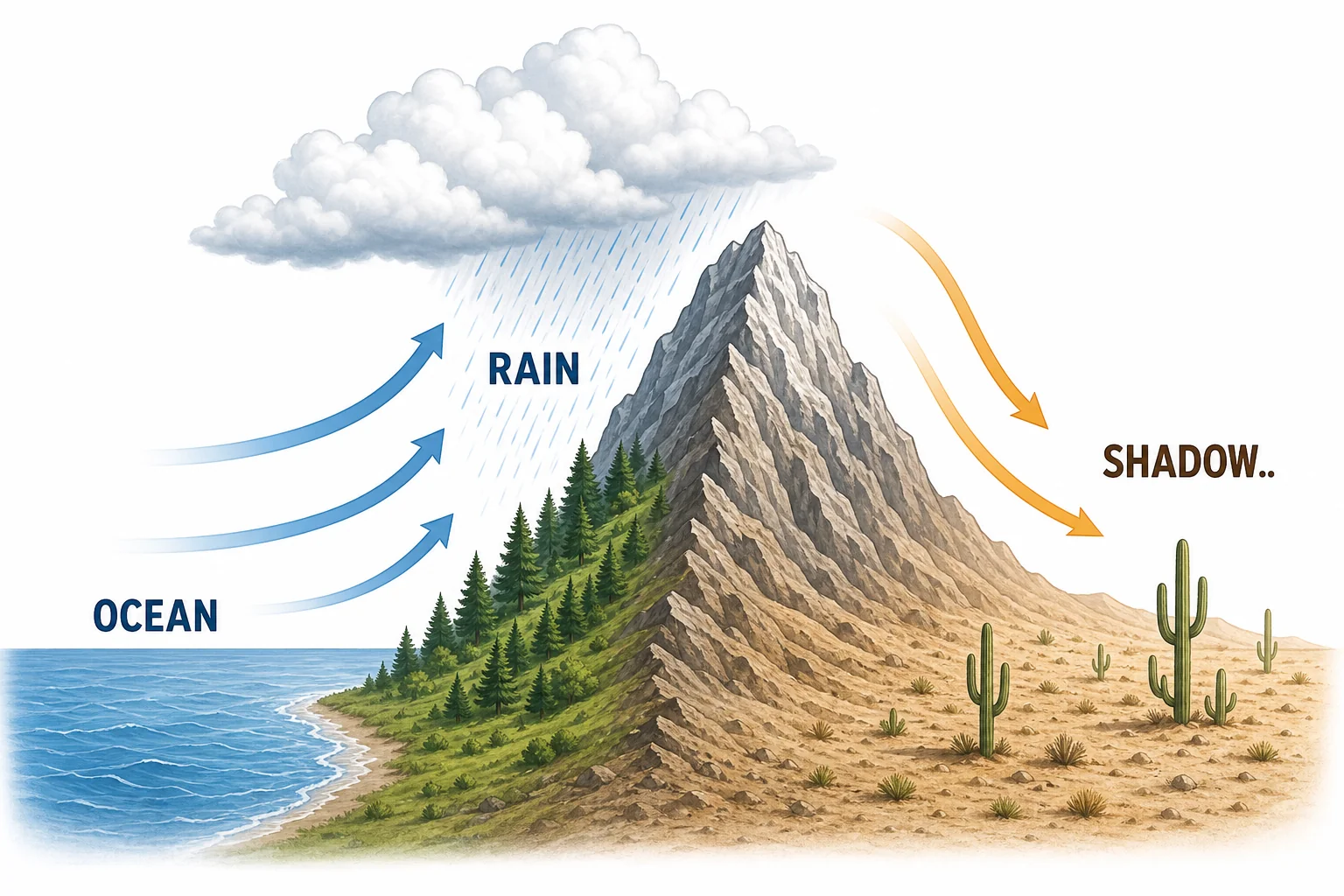
Mountain rain shadow diagram showing moist ocean air dropping rain on one side and dry air descending on the other side
Mountains can make one side wet and the other side dry
Global wind bands are only part of the story. Oceans store heat and water, so nearby land often has milder temperatures and more moisture. Winds that blow from the ocean can carry water vapor inland. When that air reaches a mountain range, it is forced upward. Rising air cools, and rain or snow falls on the windward side. By the time the air crosses the mountain, it has lost much of its moisture. The far side can become dry. This is called a rain shadow. It is one reason deserts can form next to mountains even when an ocean is not far away. Ocean currents also matter. Warm currents can add moisture to nearby air. Cold currents can cool air and reduce evaporation. A biome map is really a climate map with life added on top.

Local geography can change a biome even at the same latitude.

Plants reveal the climate
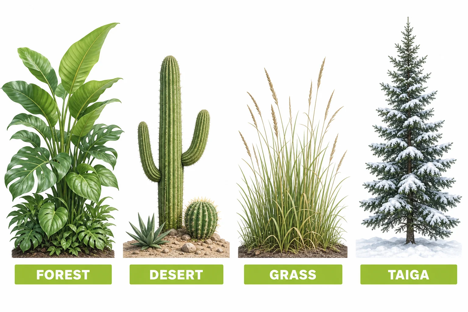
Comparison of plant adaptations in rainforest, desert, grassland, and boreal forest biomes
Plant traits show what water and temperature are like
Biomes are named mostly by their plant communities because plants are rooted in place. They cannot walk away from drought, frost, or poor soil. Their shapes tell us what the climate is like. Broad leaves are common in wet forests because plants can afford to lose water. Needle leaves help conifers reduce water loss and survive freezing winters. Desert plants may store water, grow waxy skins, or stay dormant until rain arrives. Grasslands often form where there is enough rain for grasses but not enough steady moisture for dense forests. Fire and grazing can also keep trees from taking over. Animals depend on these plant patterns. A biome is not just weather. It is the living system that develops under a long-term climate. That is why a rainforest cannot simply appear in a desert after one storm.

Plants are living evidence of long-term climate.

Biomes shift over time
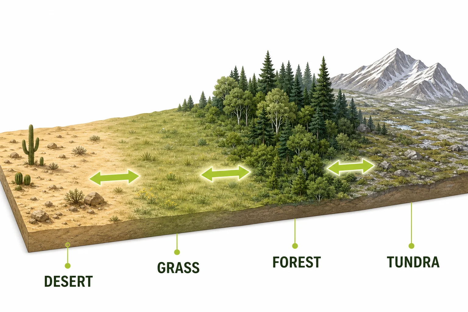
Map-style diagram showing gradual biome transition zones and arrows indicating biome boundary shifts over time
Biome edges are transition zones, not hard borders
Biome borders are not sharp lines on the ground. They are transition zones where temperature, rainfall, soil, fire, and living things change gradually. A place near the edge of a desert may have shrubs, grasses, and scattered trees. A place near the edge of tundra may have low plants mixed with small trees. Biomes also move over long periods of time. During ice ages, cold biomes spread toward the equator. During warmer periods, forests can expand into areas that were once too cold. Today, human activity is changing climate, land cover, and fire patterns. That can shift biome boundaries faster than many species can adapt or move. Scientists study biome maps, satellite images, weather records, and field data to track these changes. In class, comparing maps over time helps connect ecosystems to Earth systems.

Changing climate can move the conditions that biomes depend on.

Vocabulary

Biome
A large region with a similar climate and similar types of plants and animals.
Latitude
Distance north or south of the equator, measured in degrees.
Solar angle
The angle at which sunlight hits Earth’s surface.
Prevailing winds
Winds that usually blow from the same direction in a region.
Rain shadow
A dry area on the downwind side of a mountain range.
Climate
The usual pattern of temperature, rainfall, and weather in a place over many years.

In the Classroom

Biome Climate Sorting

25 minutes | Grades 6-8

Give students climate cards with average temperature and rainfall data. Students sort the cards into likely biomes, then explain which variable mattered most for each choice.

Rain Shadow Model

20 minutes | Grades 6-8

Students draw a mountain, ocean, wind arrows, clouds, and dry land on the far side. They use the model to explain why two places at similar latitude can have different biomes.

Biome Boundary Map

30 minutes | Grades 6-8

Students compare a biome map with a climate map. They mark places where biome edges match changes in rainfall, temperature, elevation, or distance from the ocean.

Key Takeaways

  • Biomes form because heat and rainfall are uneven across Earth.
  • Latitude affects solar angle, which helps set temperature patterns.
  • Rising and sinking air help create wet rainforest zones and dry desert zones.
  • Mountains, oceans, winds, and currents can change local climate.
  • Biome borders can shift when climate or land conditions change.